Nicaragua is the largest country in Central America, and its first tier is
fifteen departments plus two autonomous regions that fill the whole Caribbean
side. Most of the people live on the Pacific half, in departments no bigger than
a county, while most of the land is the two big regions to the east.
- The quiz
- Name to place, on the map
- Grouped by
- The Pacific, the Central North and the Caribbean
- In the game
- 17 department or regions
What you are looking at
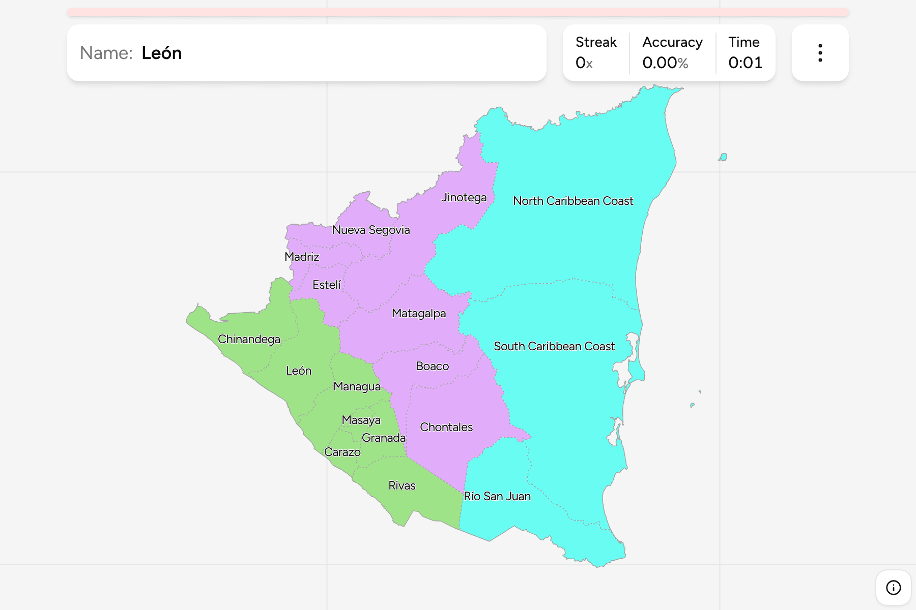
The first tier of Nicaragua: fifteen departments, and the North and South
Caribbean Coast autonomous regions, which were set up in 1987 and between them
cover about half of the country. The regions are named on the map as the North
Caribbean Coast and the South Caribbean Coast, though older maps, and the sources
this one is drawn from, still call them the North and South Atlantic.
The map is lopsided. Along the Pacific, Granada, Masaya and Carazo are small and
close together around the two big lakes, Managua and Nicaragua, while the two
Caribbean regions are each several times the size of the biggest department.
Río San Juan is the long thin one along the Costa Rican border, following the
river that gives it its name.
The groups are the three macro-regions Nicaraguans usually describe their country
by, the Pacific lowlands, the Central North highlands and the Caribbean, and no
law defines them. Río San Juan is counted with the Caribbean because its rivers
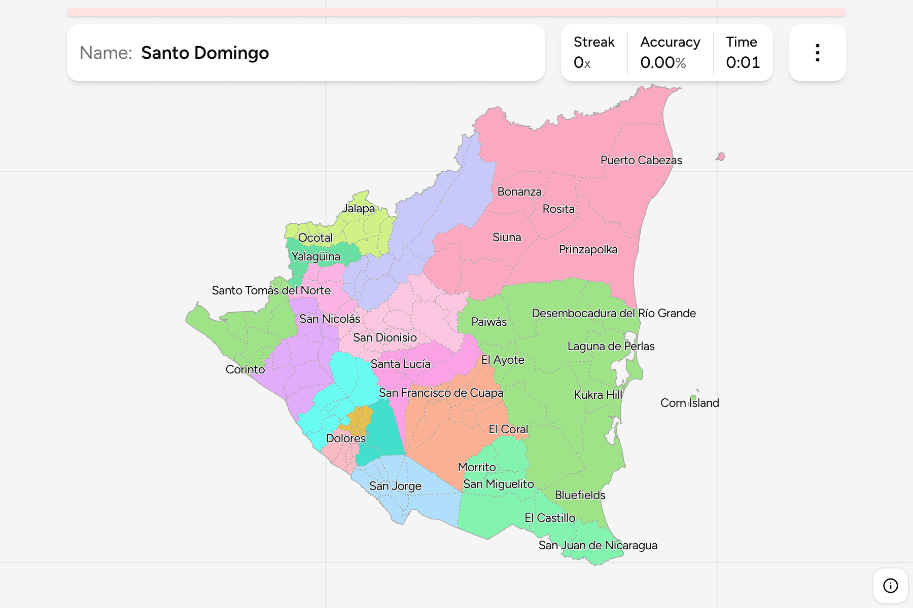
run that way. The departments are the
Nicaragua Municipalities joined together, so the
borders of the two maps match exactly.
How to place one
- Start with the lakes. Managua is the department on the south shore of Lake
Managua, with Granada and Rivas on the shore of Lake Nicaragua below it.
- Fill the Pacific strip. From the Honduran gulf, Chinandega and León run
down the coast, then Managua, Masaya, Carazo and Rivas to Costa Rica.
- Read the north as a row. Nueva Segovia, Madriz and Estelí sit along the
Honduran border, with Jinotega and Matagalpa behind them.
- Finish with the east. Boaco and Chontales are the inland cattle country,
Río San Juan follows the southern border, and the two autonomous regions take
the rest.
Every department, by group
- Pacific7 department or regions
- Carazo, Chinandega, Granada, León, Managua, Masaya, Rivas
- Central North7 department or regions
- Boaco, Chontales, Estelí, Jinotega, Madriz, Matagalpa, Nueva Segovia
- Caribbean3 department or regions
- North Caribbean Coast, South Caribbean Coast, Río San Juan
Worked examples
GranadaSmall, and on the lakeGranada is one of the smallest departments and the oldest colonial city on the
continent, on the north west shore of Lake Nicaragua. It is only four
municipalities, so once the lake is found it is the quickest to place.
North Caribbean CoastThe biggest oneThe North Caribbean Coast is the largest first-tier division, from the Honduran
border at the Coco river to the pine savannah and rainforest inland. It is
mostly empty, so a round there is more often the coast than anywhere inland.
Río San JuanThe river borderRío San Juan is the southern strip along Costa Rica, named for the river that
drains Lake Nicaragua to the Caribbean. It runs east to the sea, so it is the
department that reaches both the lake and the Caribbean coast.
Frequently asked questions
How many departments does Nicaragua have?
Fifteen, and two autonomous regions on the Caribbean coast, which are the same tier. The quiz asks all seventeen.
What are the autonomous regions?
The North and South Caribbean Coast, created in 1987 from the old department of Zelaya, which is why the Caribbean side has only two divisions.
Why are the groups not official?
Nicaragua has nothing between the departments and the country, so the Pacific, the Central North and the Caribbean are a way to drill the map, not a classification.
The tier below this one is
Nicaragua Municipalities. For a neighbour, see
Guatemala Departments.
Sources