Chad is the fifth largest country in Africa and has no coast, so its map runs
from the Sahara in the north to the green country along the Logone in the south.
Its 23 provinces cover the country without a gap, and nearly all of the people
live in the small southern provinces and around the capital, N'Djamena, while
the huge desert provinces of the north hold very few.
- The quiz
- Name to place, on the map
- Grouped by
- The Sahara, the Sahel and the south
- In the game
- 23 provinces
What you are looking at
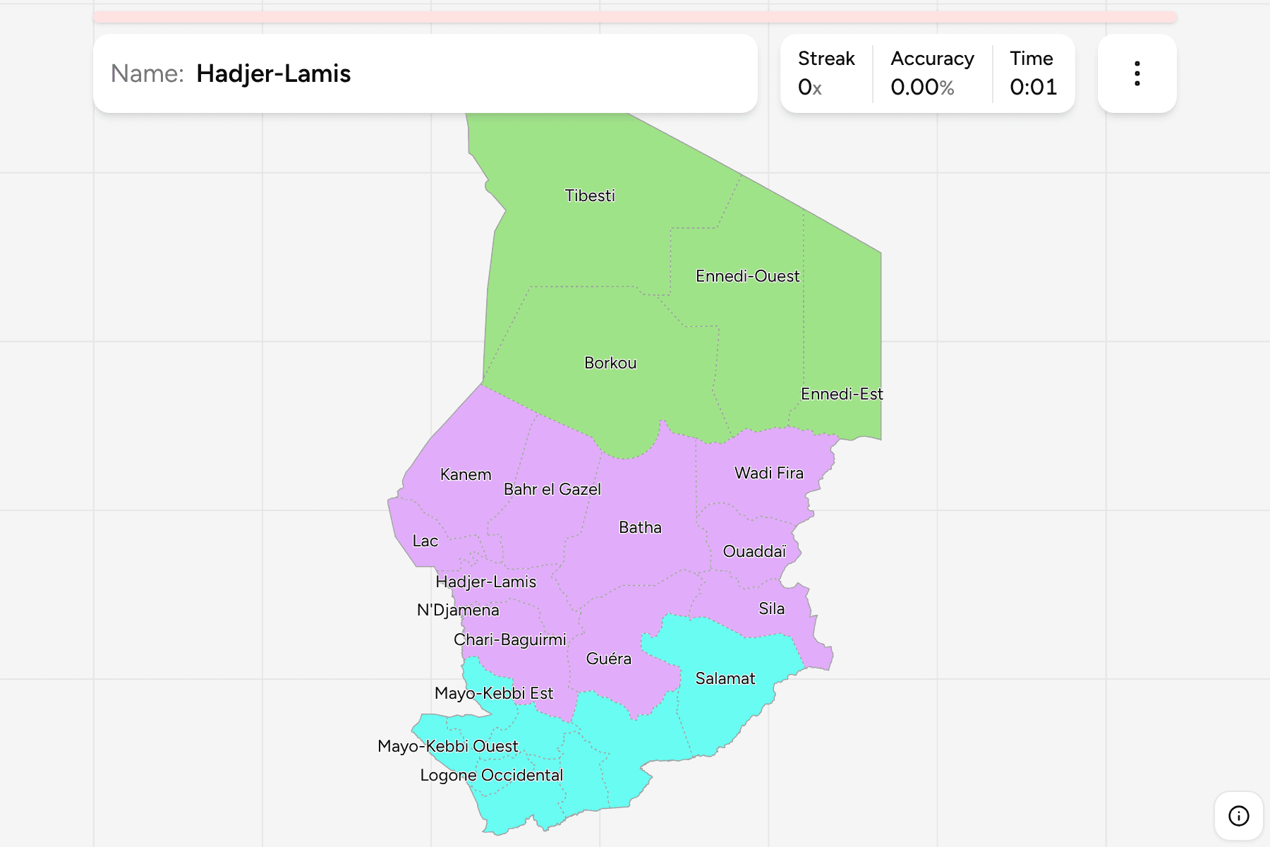
The 23 provinces of today, named the way Chad writes them. The three big desert
provinces of Tibesti, Borkou and Ennedi-Ouest fill the north and are the largest
on the map, while the provinces of the south, packed along the border with
Cameroon and the Central African Republic, are a fraction of their size.
N'Djamena is a province of its own, a tiny square on the western border.
The groups are not an official classification. They are the Saharan north, the
Sahelian centre and the southern provinces, a way to learn the map a piece at a
time.
How to place one
- Start with the capital. N'Djamena is the small province at the point where
the Chari meets the Cameroon border, in the south west.
- Climb the west. Chari-Baguirmi, Hadjer-Lamis, Lac and Kanem run up the
side, with Lac on the shores of Lake Chad.
- Cross the desert. Tibesti, Borkou and the two Ennedi provinces take up the
whole north, with Tibesti in the north west corner against Libya.
- Finish in the south. The two Logone provinces, Tandjilé, the two
Mayo-Kebbi provinces, Mandoul and Moyen-Chari fill the green south.
Every province, by group
- The Sahara4 provinces
- Borkou, Ennedi-Est, Ennedi-Ouest, Tibesti
- The Sahel11 provinces
- Bahr el Gazel, Batha, Chari-Baguirmi, Guéra, Hadjer-Lamis, Kanem, Lac, N'Djamena, Ouaddaï, Sila, Wadi Fira
- The south8 provinces
- Logone Occidental, Logone Oriental, Mandoul, Mayo-Kebbi Est, Mayo-Kebbi Ouest, Moyen-Chari, Salamat, Tandjilé
Worked examples
N'DjamenaThe capitalN'Djamena is the smallest province by far, a pocket on the western border
between Chari-Baguirmi and Cameroon.
TibestiThe largestTibesti is the largest province, a block of volcanic mountains and desert in
the far north, with Borkou to its south and Libya along its northern edge.
LacThe lakeLac is the province on the shore of Lake Chad, with Kanem to its north east and
Hadjer-Lamis to its south.
Frequently asked questions
How many provinces does Chad have?
23, and all of them cover land: the game has no territory outside them.
Does Chad group its provinces into regions?
Not in a way this game relies on. The groups here are the Sahara, the Sahel and the south, and they will not match every list you find.
Why is there no departments game?
Chad made 120 departments in 2024, and every map available today still draws the 70 of an older division, so a quiz built on it would be wrong.
Sources