Croatia is a crescent: a lowland plain along the Hungarian border, a mountain
spine behind the coast, and a thousand islands in the Adriatic. A round there
rarely gives you a border to read, but the road signs name a county town and the
number plates carry its code, and the county is the tier those both point to.
- The quiz
- Name to place, on the map
- Grouped by
- Statistical region: Pannonian, Adriatic and Northern Croatia, with Zagreb on its own
- In the game
- 21 counties
What you are looking at
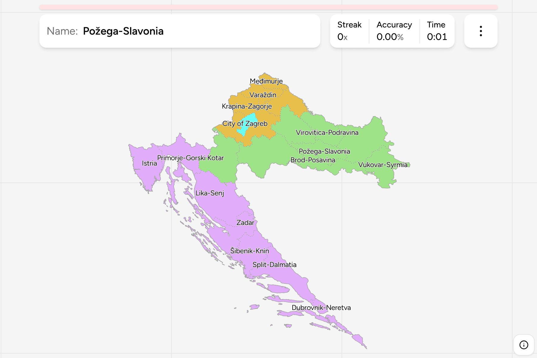
The 20 counties (županije) and the City of Zagreb, which has county rank and is
drawn as a hole in Zagreb County. The names are the English forms without the
Croatian adjectival ending, so Zadar County is Zadar and Istria is Istria.
The map is the full country, islands included. The long Dalmatian coast is
split among four counties and the northern islands between two, and the
Dubrovnik-Neretva county reaches around Bosnia's short stretch of coast at
Neum, so it comes in two pieces.
The groups are the three statistical regions Croatia reports its figures under,
with the capital on its own.
How to place one
- Start with the crescent. Slavonia is the eastern arm along the Sava and
Drava, the coast is the western one, and Zagreb sits in the hinge between.
- Count down the coast. From Istria in the northwest, the counties run
Primorje-Gorski Kotar, Lika-Senj, Zadar, Šibenik-Knin, Split-Dalmatia and
Dubrovnik-Neretva in the far south.
- Read the north from the rivers. Međimurje is the small wedge between the
Mura and the Drava, and Varaždin is the next one east.
- Leave Slavonia for last. Its five counties are a plain, and are easier from
Osijek-Baranja, the largest, outward than from their own shapes.
Every county, by region
- Pannonian Croatia8 counties
- Sisak-Moslavina, Karlovac, Bjelovar-Bilogora, Virovitica-Podravina, Požega-Slavonia, Brod-Posavina, Osijek-Baranja, Vukovar-Syrmia
- Adriatic Croatia7 counties
- Primorje-Gorski Kotar, Lika-Senj, Zadar, Šibenik-Knin, Split-Dalmatia, Istria, Dubrovnik-Neretva
- City of Zagreb1 county
- City of Zagreb
- Northern Croatia5 counties
- Zagreb County, Krapina-Zagorje, Varaždin, Koprivnica-Križevci, Međimurje
Worked examples
City of ZagrebThe capital, inside a countyThe City of Zagreb is a county of its own and sits inside Zagreb County, which
wraps it on every side and is not the same answer. It is drawn with a tap area
wider than its shape, because on a map of the whole country it is a few
pixels across.
Split-DalmatiaThe biggest oneSplit-Dalmatia is the largest county, running from the coast at Split back to
the Bosnian border, with Brač, Hvar and Vis offshore. Split is its seat.
MeđimurjeThe smallest outside the capitalMeđimurje is the northernmost county, a small wedge between Slovenia and
Hungary, and the smallest of the 20. Čakovec is its seat.
Frequently asked questions
How many counties does Croatia have?
Twenty, and the City of Zagreb, which has county rank and is counted as the twenty-first.
Why is the City of Zagreb a separate answer from Zagreb County?
They are separate units of government, though the county's offices are in the city. The quiz asks for them separately because they are separate places on the map.
What is a statistical region?
A group of counties that Croatia reports statistics under, the NUTS 2 level. Learning the groups first narrows a round down to a part of the country before the county has to be found.
For another country at this level, see Hungary Counties.
Sources