Hungary is a basin: the Danube cuts it in two, the Great Plain fills the east,
and a round there gives you few hills to go on. The county is the tier that
turns a flat field or a town on the Tisza into a place, and it is what the
number plates, the regional newspapers and the county seats are organised
around.
- The quiz
- Name to place, on the map
- Grouped by
- Statistical region: the seven regions from Central Hungary to the Southern Great Plain
- In the game
- 20 counties
What you are looking at
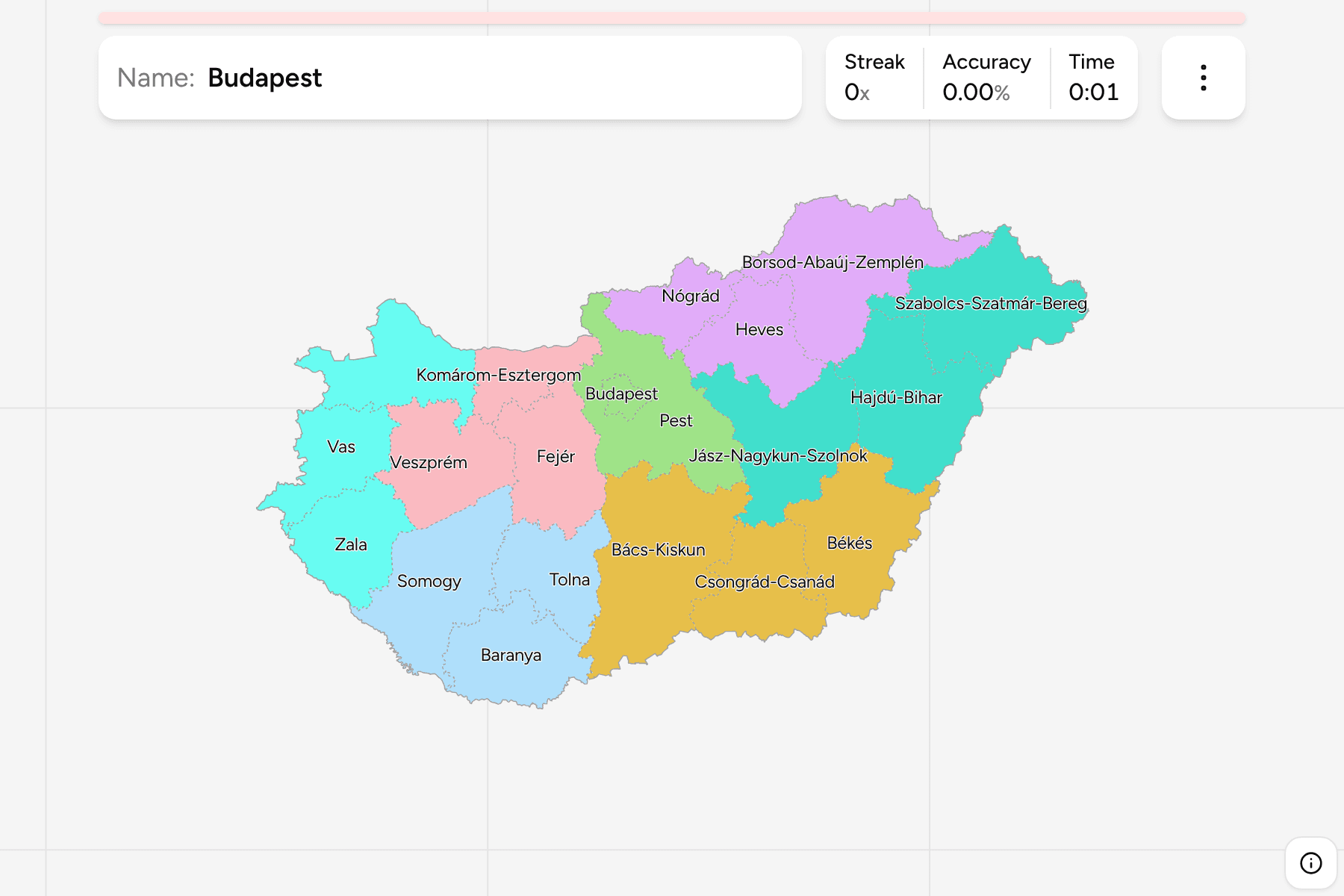
The 19 counties (megye) and the capital, which is a county of its own in every
way that matters here. Budapest sits inside Pest County and is drawn as a hole in
it: Pest is the county that wraps the capital, and its seat is Budapest all the
same.
The map keeps the 2020 name of Csongrád-Csanád, which was Csongrád until then.
Several names are doubled or tripled, because each county was made by joining
historic ones: Borsod-Abaúj-Zemplén, Szabolcs-Szatmár-Bereg and Jász-Nagykun-Szolnok
are all three counties in one.
The groups are the seven statistical regions Hungary reports its figures under.
The same regions group the districts in Hungary Districts.
How to place one
- Split the country at the Danube. West of it is Transdanubia, the hilly
half, with Győr-Moson-Sopron against the Austrian border and Baranya in the
south. East of it is the Great Plain.
- Find Lake Balaton. It runs between Veszprém and Zala to the north and
west and Somogy to the south, and it is the one landmark in the west that no
one confuses.
- Use the northern hills. Borsod-Abaúj-Zemplén, Heves and Nógrád are the
ones along the Slovak border, and Szabolcs-Szatmár-Bereg is the corner
against Ukraine and Romania.
- Leave the plain for last. Bács-Kiskun, Csongrád-Csanád and Békés in the
south and Jász-Nagykun-Szolnok in the middle share a river and a climate, and
are easier from their neighbours than on their own.
Every county, by region
- Central Hungary2 counties
- Budapest, Pest
- Northern Hungary3 counties
- Borsod-Abaúj-Zemplén, Heves, Nógrád
- Western Transdanubia3 counties
- Győr-Moson-Sopron, Vas, Zala
- Southern Great Plain3 counties
- Bács-Kiskun, Békés, Csongrád-Csanád
- Northern Great Plain3 counties
- Hajdú-Bihar, Jász-Nagykun-Szolnok, Szabolcs-Szatmár-Bereg
- Central Transdanubia3 counties
- Fejér, Komárom-Esztergom, Veszprém
- Southern Transdanubia3 counties
- Baranya, Somogy, Tolna
Worked examples
BudapestThe smallest of themBudapest is the capital and a county, about a quarter the size of the
next smallest. It is drawn with a tap area wider than its shape, because on a
map of the whole country it is a few pixels across. Zoom in for the edge.
Bács-KiskunThe biggest of themBács-Kiskun is the largest county, in the south on the Danube, and it reaches
from the Serbian border nearly to Budapest. Its seat is Kecskemét.
Komárom-EsztergomThe smallest outside the capitalKomárom-Esztergom is a thin county on the Danube, in the northwest, with the
Slovak border across the river. It is the smallest of the 19, and Tatabánya is
its seat.
Frequently asked questions
How many counties does Hungary have?
Nineteen, and the capital, which is a county of its own and is counted as the twentieth.
Why is Budapest a separate answer from Pest?
Budapest is its own unit of government, with its own assembly, though Pest County's offices are in it. The quiz asks for them separately because they are separate places on the map.
What is a statistical region?
A group of counties that Hungary reports statistics under, the NUTS 2 level. Learning the seven first narrows a round down to a corner of the country before the county has to be found.
The tier below this one is Hungary Districts. For another
country at this level, see Austria States.
Sources