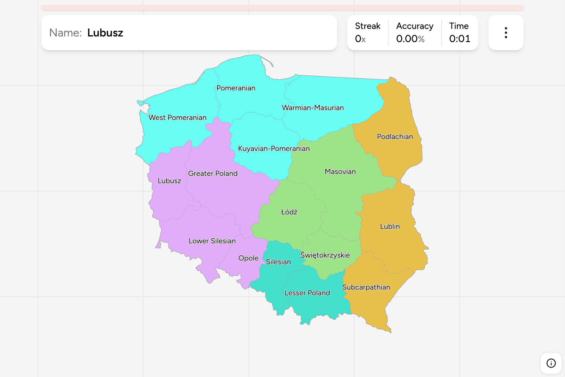
Poland's voivodeships are the rare set of administrative regions that are worth
learning as history rather than as shapes: almost every one is named after the
land it covers, and those lands are the ones Poland was assembled from. Learn
where Greater Poland, Lesser Poland, Silesia, Mazovia and Pomerania are and you
have most of the map, in Polish as well as in English. This page is the whole
set, and the game asks you to put each name where it belongs.
- The quiz
- Name to place, on the map
- Names
- English or Polish
- In the game
- 16 voivodeships
What you are looking at
A województwo is Poland's top level of local government, and it is run twice
over: an elected assembly with a marshal at its head does the governing, and a
voivode appointed from Warsaw represents the state. The word is old, the
institution is not. This particular set of them dates from 1 January 1999, when
a reform replaced the 49 small voivodeships of the communist period with 16
large ones drawn to match the historical provinces. Those 49 are still visible
in the country if you know where to look, because the telephone area codes were
never redrawn to match.
In Polish the name is an adjective agreeing with the word województwo, which is
why they all end in -skie or -ckie, and why the name on a sign is Małopolskie
rather than Małopolska. Most are the adjective of a region: Wielkopolskie is
Greater Poland, the cradle of the state around Poznań, and Małopolskie is
Lesser Poland around Kraków, where great and lesser mean older and younger
rather than bigger and smaller. Three take the name of their capital city
instead, and one is named after a range of hills.
The single best clue on the ground is the number plate. Every Polish plate
begins with one letter that identifies the voivodeship, followed by a district
code: W is Mazowieckie, K is Małopolskie, G is Pomorskie. It is not a clean
rule, since some letters come from the region and some from its capital, but it
is one glance and it narrows the country to a sixteenth. Nothing else about
Polish roads varies by region: the signs, the markings and the guardrails are
national.
How to place one
- Start at the coast. Three voivodeships run along the Baltic, and going
west to east they are West Pomeranian, Pomeranian and Warmian-Masurian, the
last of which is the lake district rather than the coast proper.
- Then the two capitals. Masovian is the big one in the middle east, with
Warsaw in it, and it is the largest voivodeship in the country. Lesser
Poland is the southern one with Kraków, up against the Tatras.
- Then the corners. Silesia is the industrial block in the south, on the
Czech border. Lower Silesia is west of it, with Wrocław. Greater Poland is
the wide one in the middle west, with Poznań. The eastern wall against
Belarus and Ukraine is three: Podlachian in the northeast, Lublin in the
middle, Subcarpathian in the southeast corner.
- Fill in the small ones last. What remains are the ones that fit between
the big names: Kuyavian-Pomeranian below Pomeranian, Lubusz on the German
border, Opole between the two Silesias, Łódź in the exact centre of the
country, and Świętokrzyskie under it.
Two pairs cause most of the mistakes, and both are pairs of names rather than
pairs of places. Lubusz and Lublin sound almost the same and sit at opposite
ends of the country, one against Germany and one against Ukraine. Podlachian
and Subcarpathian both begin with pod, which means under, and they are the
northeast and southeast corners respectively: one is under the forest, the
other under the mountains.
The third trap is Pomerania, which turns up in three names. Two of them are on
the Baltic and one is not: Kuyavian-Pomeranian is landlocked, sitting below the
other two, and carries the name because its northern half is the inland end of
Pomerania along the lower Vistula.
Every voivodeship, by part of the country
- Centre3 voivodeships
- Łódź (Łódzkie), Masovian (Mazowieckie), Świętokrzyskie
- West4 voivodeships
- Lubusz (Lubuskie), Greater Poland (Wielkopolskie), Lower Silesian (Dolnośląskie), Opole (Opolskie)
- North4 voivodeships
- West Pomeranian (Zachodniopomorskie), Pomeranian (Pomorskie), Warmian-Masurian (Warmińsko-mazurskie), Kuyavian-Pomeranian (Kujawsko-pomorskie)
- East3 voivodeships
- Podlachian (Podlaskie), Lublin (Lubelskie), Subcarpathian (Podkarpackie)
- South2 voivodeships
- Silesian (Śląskie), Lesser Poland (Małopolskie)
The name in brackets is the Polish one, which is what a boundary sign, a
weather map and a car registration all use, and what the game shows if you turn
on the local name in the start dialog. Learning that pairing is most of the
value of this map, because the English name is almost never the one you will be
looking at. Each group can be played on its own from the start dialog.
Worked examples
LubuszNot the one that sounds like itA narrow voivodeship on the German border, named after the town of Lubusz,
which is now on the German side of the river. It is the one people put in the
east because its name is a syllable away from Lublin, which is genuinely in
the east, roughly five hundred kilometres away. It also has two capitals, one
for the assembly and one for the voivode.
Warmian-MasurianLakes rather than coastThe northeastern corner, and the one that breaks the coastal run: it touches
the Baltic only at the lagoon, and what it is actually made of is the
Masurian lake district and the old Prussian province of Warmia below it. Two
historical lands in one name, which is a pattern worth recognising because it
is how three of these were built.
ŚwiętokrzyskieNamed after hillsThe small one in the middle south, and the only one whose name comes from
neither a city nor a province: it is the adjective of the Świętokrzyskie
Mountains, the Holy Cross range, which are the oldest and lowest mountains in
Poland. Its capital, Kielce, is not in its name at all, which is why it is
hard to place from the name alone and worth learning as a shape.
MasovianThe biggest oneThe largest voivodeship by area and by population, holding Warsaw in the
middle of it and a great deal of farmland around that. Because the capital
sits inside rather than on the edge, this one is usually the first thing
placed on the map and the anchor everything east of centre is measured from.
Frequently asked questions
How many voivodeships does Poland have?
16, and they have covered the whole country since 1 January 1999. Before that there were 49, created in 1975, and before those 17. The 1999 reform was explicitly an attempt to go back to regions people recognised, which is why so many of the current names are historical provinces.
What is a voivodeship?
The top level of local government in Poland, in Polish a województwo. Each has an elected assembly with a marshal at its head, which handles regional development, roads and hospitals, and a voivode appointed by the national government, who represents the state and supervises legality. The word voivode is an old Slavic title for a war leader, and it survives here as a job in a regional administration.
Why do Polish region names all end in -skie?
Because the name is an adjective agreeing with the neuter noun województwo. Written in full it is województwo małopolskie, the Lesser Poland voivodeship, and the noun is usually dropped, leaving the adjective standing alone as the name. That is why maps and signs read Małopolskie rather than Małopolska, which is what the region itself is called.
How can you tell which voivodeship a photo is in?
The number plate. Every Polish plate starts with a single letter for the voivodeship and then a code for the district within it, so one letter narrows the country to a sixteenth and the pair usually names a town. There is no other regional variation to read: Polish road signs, markings, bollards and guardrails are the same nationwide.
Which voivodeship is the largest?
Masovian, both by area and by population, with Warsaw inside it. Opole is the smallest on both counts. Silesian is the most densely populated by a wide margin, because it holds the Upper Silesian industrial belt, which is the largest continuous urban area in the country.
Which Polish voivodeships are easiest to confuse?
Lubusz and Lublin, which sound alike and sit at opposite borders, the German one and the Ukrainian one. Podlachian and Subcarpathian, which share a prefix and are the northeast and southeast corners. And the three names containing Pomerania, of which West Pomeranian and Pomeranian are on the Baltic in that order from the west, while Kuyavian-Pomeranian is inland below them.
More European maps in the same shape: Germany States,
France Dialing Codes and Spain Dialing
Codes. The 49 voivodeships this map replaced are still
the shape of the country's phone numbers, which is a game of its own: Poland
Dialing Codes.
Sources