Germany is a federation, and the states are the parts it is a federation of:
each one runs its own schools, its own police and its own broadcaster, which is
why a German talking about home names a state rather than a region. The shapes
are the awkward part, because half of them were drawn by occupation
administrators in 1946 and owe nothing to anything older. This page is the whole
set, and the game asks you to put each name where it belongs, in English or the
way it is written in German.
- The quiz
- Name to place, on the map
- Names
- English or German
- In the game
- 16 states
What you are looking at
The word is Land, plural Länder, and Bundesland when it needs distinguishing
from a country. Each has a parliament, a constitution and a capital of its own,
and the powers they keep are the ones you notice: policing, schooling,
broadcasting and the roads below motorway level. Three of them are cities
rather than territories, which is a category worth knowing before you look for
them on the map, because two are small enough to miss and the third is inside
another state.
The map is younger than the country. The British, American and French
administrations drew most of these borders in 1946 and 1947 out of what was
left of Prussia and the old kingdoms, which is why several states are visibly
a couple of historical pieces stapled together and say so in their names.
Baden-Württemberg was voted into existence out of three of them in 1952.
Saarland was a French protectorate and only joined in 1957. The five eastern
states were abolished in 1952, replaced by districts, and re-established in
1990 on the borders they had lost, which is why the eastern quarter of this map
looks older than it is.
Germany signs itself almost identically from end to end, so the state is rarely
written on anything at the roadside. What gives it away instead is a number
plate, whose first letters name a town and therefore a state, the coat of arms
on the round seal beside them, a boundary sign with a crest on it, and the
guardrail, which really does change at some of these borders.
How to place one
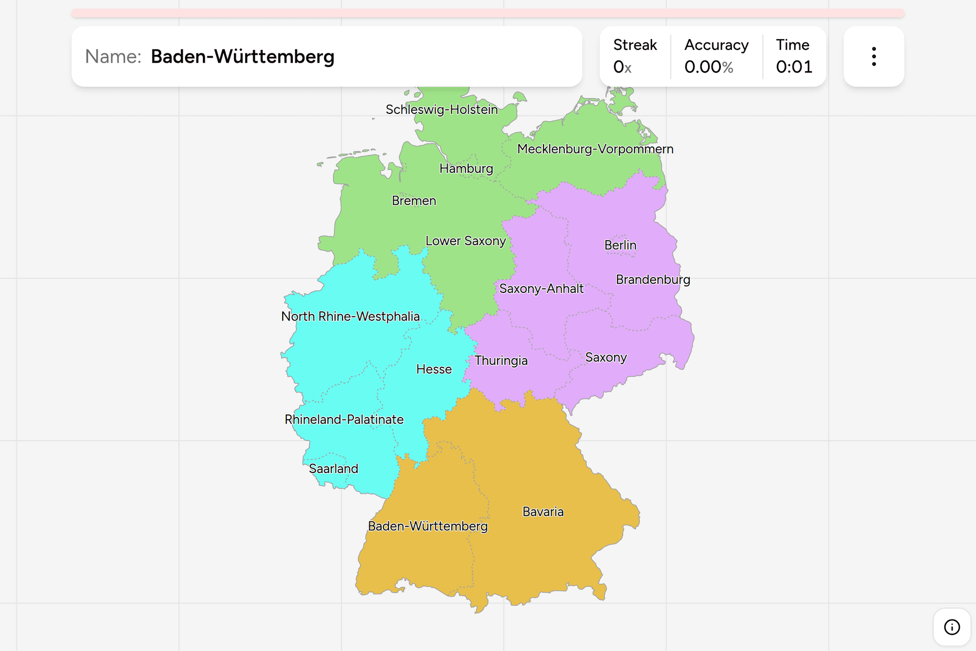
- Take the south first. Two states cover it, and they are the two biggest
blocks on the map: Bavaria in the southeast against Austria and Czechia,
Baden-Württemberg in the southwest against France and Switzerland. Together
they are a third of the country and they cannot be confused with anything.
- Then the coast. The neck of land reaching for Denmark is one state, the
Baltic coast east of it is another, and the wide one below them running from
the Dutch border to the Elbe is Lower Saxony, which is the second largest
state and the one people underestimate. Hamburg sits on the Elbe between
them; Bremen is a notch in Lower Saxony, sixty kilometres inland, with a
second piece at the river mouth.
- Then the east. Five states, stacked from the Baltic down to the Czech
border: Brandenburg wrapping Berlin, Saxony-Anhalt to its west, Saxony in
the southeast corner around Dresden and Leipzig, Thuringia west of Saxony.
- What is left is the west. North Rhine-Westphalia is the populous one on
the Dutch border, Hesse is east of it with Frankfurt in the middle,
Rhineland-Palatinate is below Hesse along the Rhine and the Moselle, and the
small one wedged into the French corner is Saarland.
The traps here are names rather than shapes. Three states are called some kind
of Saxony and no two of them touch in the way you would expect: the one simply
called Saxony is in the far southeast, Saxony-Anhalt is north of it, and Lower
Saxony is not near either, being the big one in the northwest. The pair on the
Baltic get swapped in the other direction, since Mecklenburg-Vorpommern is the
coastal one and Brandenburg the landlocked one below it, and the long name
tempts people into making it the bigger of the two.
The city states are free points once you have looked for them once. Berlin is a
hole in Brandenburg, Hamburg is a small patch straddling the Elbe, and Bremen
is the one people never find because they are scanning for something the size
of a state.
Every state, by quarter of the map
- North5 states
- Schleswig-Holstein, Hamburg, Bremen, Lower Saxony (Niedersachsen), Mecklenburg-Vorpommern
- East5 states
- Berlin, Brandenburg, Saxony-Anhalt (Sachsen-Anhalt), Saxony (Sachsen), Thuringia (Thüringen)
- West4 states
- North Rhine-Westphalia (Nordrhein-Westfalen), Hesse (Hessen), Rhineland-Palatinate (Rheinland-Pfalz), Saarland
- South2 states
- Baden-Württemberg, Bavaria (Bayern)
The name in brackets is the German one, which is what the boundary sign, the
weather forecast and the plate registry all use, and what the game shows if you
turn on the local name in the start dialog. Roughly half the set is the same
word either way. Each quarter can be played on its own, and the south is a
two question drill while the east is a real one.
Worked examples
Lower SaxonyNot near SaxonyThe second largest state, filling the northwest from the Dutch border to the
Elbe, and the reason the Saxony names are a mess. The Saxon homeland was
here; the ducal title travelled southeast in the Middle Ages and took the
name with it, leaving the original in the corner it started in and two
younger Saxonies four hundred kilometres away.
BremenThe smallest oneA state of two cities and nothing in between: the port sixty kilometres up
the Weser and its outport at the river mouth, both enclaves inside Lower
Saxony. It is the smallest state by area and by population, the only one in
two pieces, and the click most often missed on this map.
BrandenburgThe ringThe state that surrounds the capital completely without including it. Berlin
was a separate case throughout the division and stayed one afterwards, so
what looks like one metropolitan region on the ground is two states, and a
vote to merge them failed in 1996.
SaarlandThe odd one outThe smallest of the territorial states, in the southwestern corner against
France, and the last to join: it was a French protectorate until a referendum
sent it back, and it entered the federation in 1957. Small, but a full state
with a parliament of its own, which is a fact worth having when you are
counting.
Frequently asked questions
How many states does Germany have?
16. Thirteen are territorial states and three are cities that are states in their own right: Berlin, Hamburg and Bremen. All 16 sit at the same level, with their own parliament, their own constitution and their own police force.
What is a Bundesland?
A member state of the German federation, called a Land in official use. The federal government handles defence, foreign affairs and most taxation; the states handle education, policing, broadcasting and much of the road network, and they are represented in national lawmaking through the Bundesrat.
Why are there three states called Saxony?
Because the name moved and the land did not. The old Saxon duchy was in the northwest, where Lower Saxony is today. When the duchy was broken up in 1180 the ducal title went to a family holding land on the middle Elbe, and over the following centuries the name Saxony settled there instead. The modern Free State of Saxony is that eastern territory, Saxony-Anhalt is the ground between it and the old homeland, and Lower Saxony keeps the original meaning of the word.
Which German state is the largest?
Bavaria by a wide margin in area, covering roughly a fifth of the country, with Lower Saxony second. North Rhine-Westphalia is the largest by population, with about a fifth of all Germans in a much smaller space. Bremen is the smallest on both counts.
How can you tell which German state a photo is in?
The number plate is the fastest way, because its first letters are a town or district code and each one belongs to exactly one state, and the round seal beside them carries that state's coat of arms. Failing that, a boundary sign with a crest, the guardrail profile, which changes at some state borders, and the architecture, which shifts from brick along the Baltic to timber framing through the middle and stone in the Alps.
When were Germany's states created?
Most of them in 1946 and 1947, by the western occupation administrations, out of Prussian provinces and the older kingdoms. Baden-Württemberg was merged from three states in 1952 and Saarland joined in 1957. The five eastern states were dissolved into districts in 1952 and re-established in 1990 at reunification, which is why the current map is only as old as the country in its present form.
The tier below this one, and the one that hands out the letters on a number
plate, is Germany Districts. More European maps in the
same shape: Poland Voivodeships, Poland Dialing
Codes, France Dialing Codes
and Spain Dialing Codes. The clue that changes at some
of these very borders has a game of its own: Germany
Guardrails.
Sources
- States of Germany, the list, the three city states, and how the current map was drawn
- Natural Earth, the admin-1 boundaries this game's map is built from