Slovenia is small enough to cross in an afternoon, and it still packs in the
Julian Alps, the Karst plateau, a short stretch of Adriatic coast and the flat
Pannonian plain along the Hungarian border. The twelve statistical regions are
how the country talks about itself in its own statistics, and they are the
tier worth learning before the municipalities.
- The quiz
- Name to place, on the map
- Grouped by
- Cohesion region: Eastern and Western Slovenia
- In the game
- 12 regions
What you are looking at
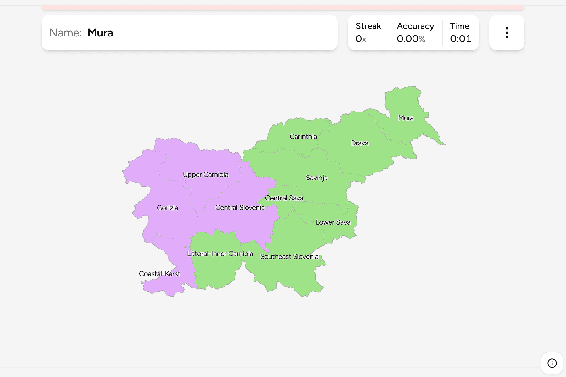
The statistične regije: twelve regions that
Statistics Slovenia and Eurostat use as NUTS 3. They have no government of their
own, which is why the country has no signs that say "welcome to Gorenjska", but
they are what a Slovene means by "the Primorska" or "the Štajerska", and most
are named for a river or a historic land.
The English names are the common ones (Upper Carniola, Mura, Savinja), and the
local name is a switch in the start dialog: Upper Carniola is Gorenjska, Mura is
Pomurska. The Central Sava region, a mining and industrial valley, is the
smallest of the twelve.
The groups are the two cohesion regions the country is split into for EU
funding: Eastern Slovenia, which holds the Mura, Drava and Savinja valleys and
everything south-east of them, and Western Slovenia, which is Ljubljana, the
Alps and the coast. The regions are the municipalities of
Slovenia Municipalities dissolved, so the borders of
the two maps match exactly.
How to place one
- Start with Central Slovenia. It is the region around Ljubljana, in the
middle of the country, and almost every other region touches it.
- Follow the Alps north. Upper Carniola is the Alpine region to its north,
Carinthia is the small one pressed against the Austrian border to the north
east, and Gorizia is the long region in the west along the Italian border.
- Read the east as river valleys. Mura is the flat corner against Hungary,
Drava is the region around Maribor, and Savinja is the one around Celje.
- Finish on the south and the coast. Southeast Slovenia and Lower Sava lie
along the Croatian border, Littoral-Inner Carniola is the Karst between
Ljubljana and the sea, and Coastal-Karst is the sliver that actually
touches the Adriatic.
Every region, by cohesion region
- East8 regions
- Carinthia, Central Sava, Drava, Littoral-Inner Carniola, Lower Sava, Mura, Savinja, Southeast Slovenia
- West4 regions
- Central Slovenia, Coastal-Karst, Gorizia, Upper Carniola
Worked examples
Central SloveniaThe capital regionCentral Slovenia holds Ljubljana and a quarter of the country's people. It is
the hub of the map, and a good first answer because everything else is described
as being north, south or east of it.
Coastal-KarstThe one with the seaSlovenia has about forty-six kilometres of coast, and Coastal-Karst is all of
it: Koper, Izola, Piran and the new municipality of Ankaran. It is Italian as well
as Slovene on the signs, and one of the smallest regions on the map.
Central SavaThe smallest of themCentral Sava is a handful of mining and industrial towns, Trbovlje, Hrastnik and
Zagorje ob Savi among them, in a deep valley between Ljubljana and Celje. It is
the smallest region by a wide margin, and the one most often skipped.
Frequently asked questions
How many regions does Slovenia have?
Twelve statistical regions. They are not administrative regions with a government: the country has municipalities and, for state business, administrative units, and the regions sit above them for statistics and planning.
What is the difference between a statistical region and a cohesion region?
The twelve are NUTS 3. Eurostat groups them into two cohesion regions, NUTS 2, Eastern Slovenia and Western Slovenia, which is how EU funds are divided. The groups in this quiz are those two.
Are there older regions Slovenes still use?
It does: the historic lands of Carniola, Styria, Carinthia and the Littoral are how Slovenes still talk about the map. They do not line up with the statistical regions, which is why this quiz uses the statistical ones.
The tier below this one is Slovenia Municipalities,
whose regions are the groups there. For another small country at this level, see
Austria States.
Sources