Greece is a mainland, a peninsula and a sea full of islands, and a region is
usually a good guess at which of the three a place is on. There are thirteen of
them, and they are the tier that a Greek road sign, a licence plate or a weather
map starts from.
- The quiz
- Name to place, on the map
- Grouped by
- Part of the country: the north, the centre, the Peloponnese and Ionian, and the Aegean and Crete
- In the game
- 14 regions
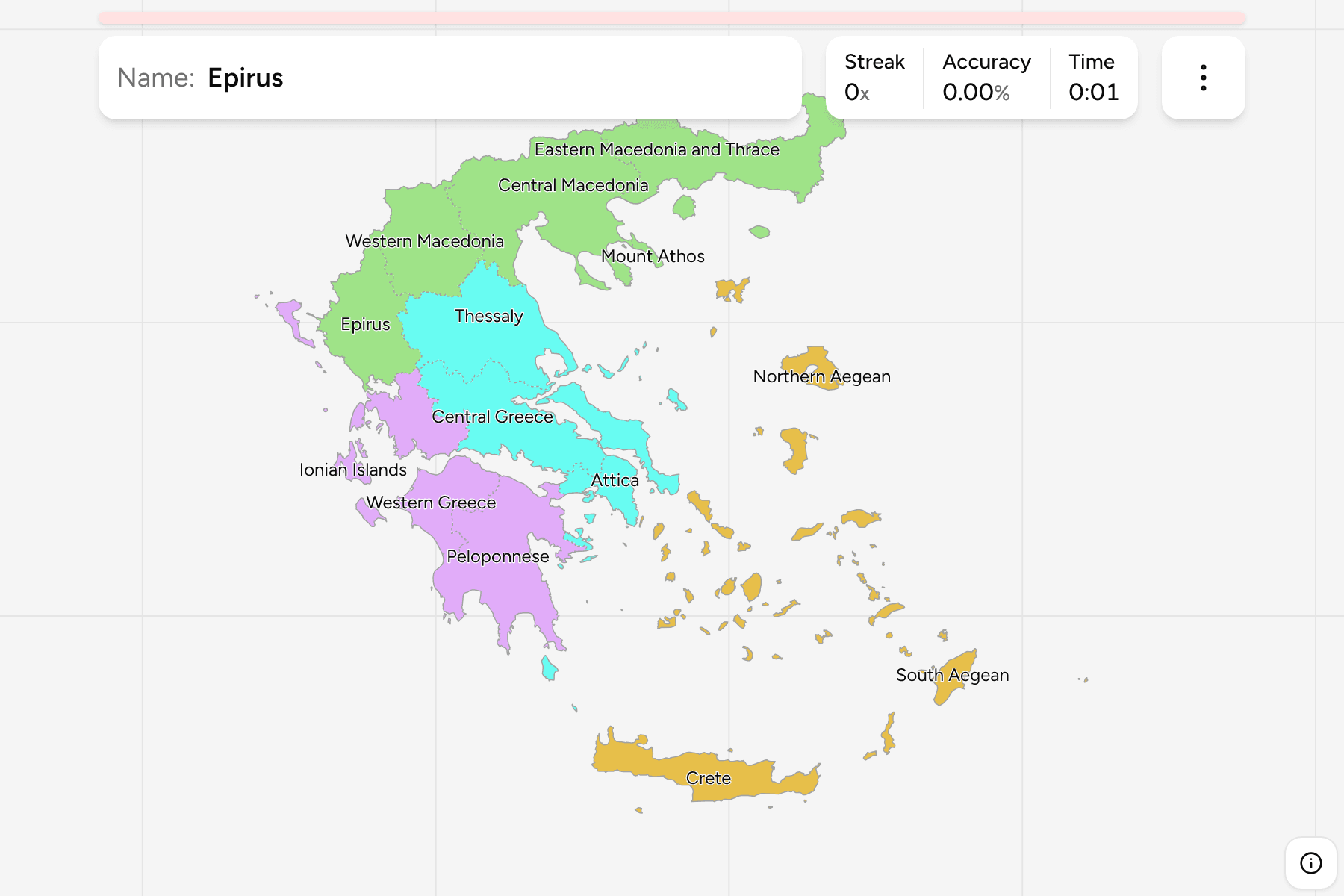
What you are looking at
The thirteen peripheries that the 2011 Kallikratis reform drew, plus Mount Athos,
which belongs to none of them. The Holy Mountain is a self-governing monastic
state under Greek sovereignty, and it is the small shape on the end of the
easternmost prong of Chalkidiki, so it has a tap area wider than its outline.
Three of the regions are mostly islands. The South Aegean is the Cyclades and
the Dodecanese, which is why it comes out as dozens of separate pieces across
five degrees of longitude; the North Aegean is the big islands along the Turkish
coast, from Lesbos to Ikaria; and the Ionian Islands run down the west side,
from Corfu to Zakynthos. Crete is the only one that is a single island.
The groups are ours: each is a union of whole decentralised administrations, the
seven state bodies that sit above the regions, so none of them parts one. That
puts Epirus with Western Macedonia in the north, Thessaly and Attica in the
centre, and Crete with the Aegean. The regions are the
regional units dissolved, so the borders of the two
maps match exactly.
How to place one
- Start in Attica. It is the arrowhead pointing into the Aegean south east
of the mainland, and Athens fills most of it.
- Read the north from west to east. Epirus, Western Macedonia, Central
Macedonia and Eastern Macedonia and Thrace follow the northern border in that
order, and Thessaly sits under the first two.
- Find the peninsula. The Peloponnese hangs off the mainland by the Isthmus
of Corinth, with Western Greece taking its north west corner and the rest of
the western coast.
- Sort the islands by sea. The Ionian ones are in the west, the North Aegean
ones hug Turkey, the South Aegean ones are in the middle and south east, and
Crete is the long one at the bottom.
Every region, by group
- North5 regions
- Central Macedonia, Eastern Macedonia and Thrace, Epirus, Mount Athos, Western Macedonia
- Peloponnese and Ionian3 regions
- Ionian Islands, Peloponnese, Western Greece
- Centre3 regions
- Attica, Central Greece, Thessaly
- Aegean and Crete3 regions
- Crete, Northern Aegean, South Aegean
Worked examples
Mount AthosThe one that is not a regionMount Athos has been self-governed by its twenty monasteries since the
Byzantine era, and the Greek constitution names it an autonomous part of the
state. It is a quiz answer because it is a shape on every map of the country,
and the one most likely to be missed because it is so small.
South AegeanThe one in the most piecesThe South Aegean is the Cyclades and the Dodecanese under one region. Rhodes
is the biggest island in it, and the whole region has less land than Epirus.
Western GreeceThe one that is not in the westWestern Greece takes in the north west of the Peloponnese as well as the
mainland across the Gulf of Patras, so the biggest city in it, Patras, sits on
the peninsula.
Frequently asked questions
How many regions does Greece have?
Thirteen, since the Kallikratis reform of 2011. Mount Athos is a self-governing monastic state and is not part of any of them, but it is on the map as a fourteenth answer.
Are the regions the same as the old prefectures?
No. The 54 prefectures were replaced in 2011 by 74 regional units, and the regions are the tier above those. Most of the regional units have the name of a prefecture they replaced.
Why is Attica in the centre group?
Because it is a decentralised administration of its own, and the groups are made of whole ones. Attica and Thessaly with Central Greece are the two that make up the centre.
The tier below this one is Greece Regional Units. For
another country at this level, see Italy Regions.
Sources