The Central African Republic is a landlocked country of 623,000 square
kilometres, and its prefectures are what anyone there uses to say where
something is: Ouham-Pendé for the north-west, Haute-Kotto for the empty
north-east, Mbomou for the Ubangi frontier with the Congo. The list has grown
since many maps were drawn, so one that is more than a few years old is likely
to be missing a prefecture or two.
- The quiz
- Name to place, on the map
- Grouped by
- Where they lie: North-East, South-East, Centre, North-West and South-West
- In the game
- 20 prefectures
What you are looking at
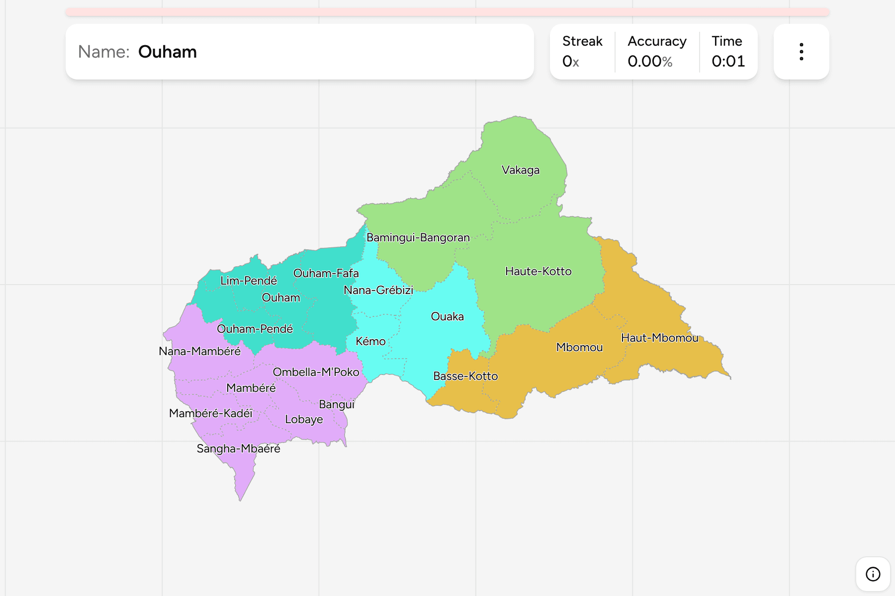
The prefectures (préfectures) of the Central African Republic, the first tier of
the country, with the capital Bangui as a prefecture of its own. Several names
are a river or a pair of them: the Ouham and the Pendé, the Mambéré and the
Kadéï, the Kotto and the Mbomou. Where a name comes in a pair, learn the pair
together, because the prefectures sit next to one another on the map.
Some of the newest are cut from older ones: Lim-Pendé from Ouham-Pendé,
Ouham-Fafa from Ouham and Mambéré from Mambéré-Kadéï. Older maps draw the
longer list of names as one prefecture each, so the file used here, which draws
all 20, is the reason this map differs from the one on a wall.
The groups are ours rather than the country's, since no official level sits
between the prefecture and the country. They cut the map by where the
prefectures lie, which is enough to learn it one piece at a time. The
prefectures are the Central African Republic Sub-prefectures
grouped, so the borders of the two maps match exactly.
How to place one
- Start at the capital. Bangui is on the Ubangi in the south, with
Ombella-M'Poko wrapped round it and Lobaye below.
- Read the south-west as a row. From Sangha-Mbaéré on the Cameroon border,
Mambéré-Kadéï, Mambéré and Nana-Mambéré run up the western frontier.
- Cross the north-west. Ouham-Pendé and Lim-Pendé sit against Chad, with
Ouham and Ouham-Fafa behind them.
- Finish in the east. Haute-Kotto and Vakaga fill the large north-east, and
Basse-Kotto, Mbomou and Haut-Mbomou follow the Ubangi round the south-east.
Every prefecture, by group
- North-East3 prefectures
- Bamingui-Bangoran, Haute-Kotto, Vakaga
- South-West7 prefectures
- Bangui, Lobaye, Mambéré, Mambéré-Kadéï, Nana-Mambéré, Ombella-M'Poko, Sangha-Mbaéré
- Centre3 prefectures
- Kémo, Nana-Grébizi, Ouaka
- South-East3 prefectures
- Basse-Kotto, Haut-Mbomou, Mbomou
- North-West4 prefectures
- Lim-Pendé, Ouham, Ouham-Fafa, Ouham-Pendé
Worked examples
Haute-KottoThe biggest of themHaute-Kotto is the largest prefecture, a broad stretch of the east and
north-east around the Kotto river and the diamond towns.
BanguiThe smallest of themBangui is the smallest prefecture, the capital and the communes around it on
the north bank of the Ubangi, with Ombella-M'Poko on its other sides.
Lim-PendéOne of the newestLim-Pendé was cut from Ouham-Pendé around Paoua, in the north-west. Older maps
draw it as part of its parent.
Frequently asked questions
How many prefectures does the Central African Republic have?
20 on this map, counting Bangui as one and including Lim-Pendé, Ouham-Fafa and Mambéré, which older maps leave out.
Why are the groups not official?
No official level sits between the prefecture and the country, so the groups are ours, cut by where the prefectures lie.
What is below the prefecture?
The sub-prefectures, which number 85 on this map. They are their own quiz.
The tier below this one is Central African Republic Sub-prefectures.
For another country at this level, see Chad Provinces.
Sources