Sierra Leone is a small country with a short list: the district is the tier
that holds the local council, the district medical officer and the paramount
chiefs, and it is the name used for exam results, elections and aid maps. The
list is short enough to learn in an evening, and a few of the names were made
only recently, which is where most players slip.
- The quiz
- Name to place, on the map
- Grouped by
- Province: Eastern, Northern, North Western and Southern, plus the Western Area
- In the game
- 16 districts
What you are looking at
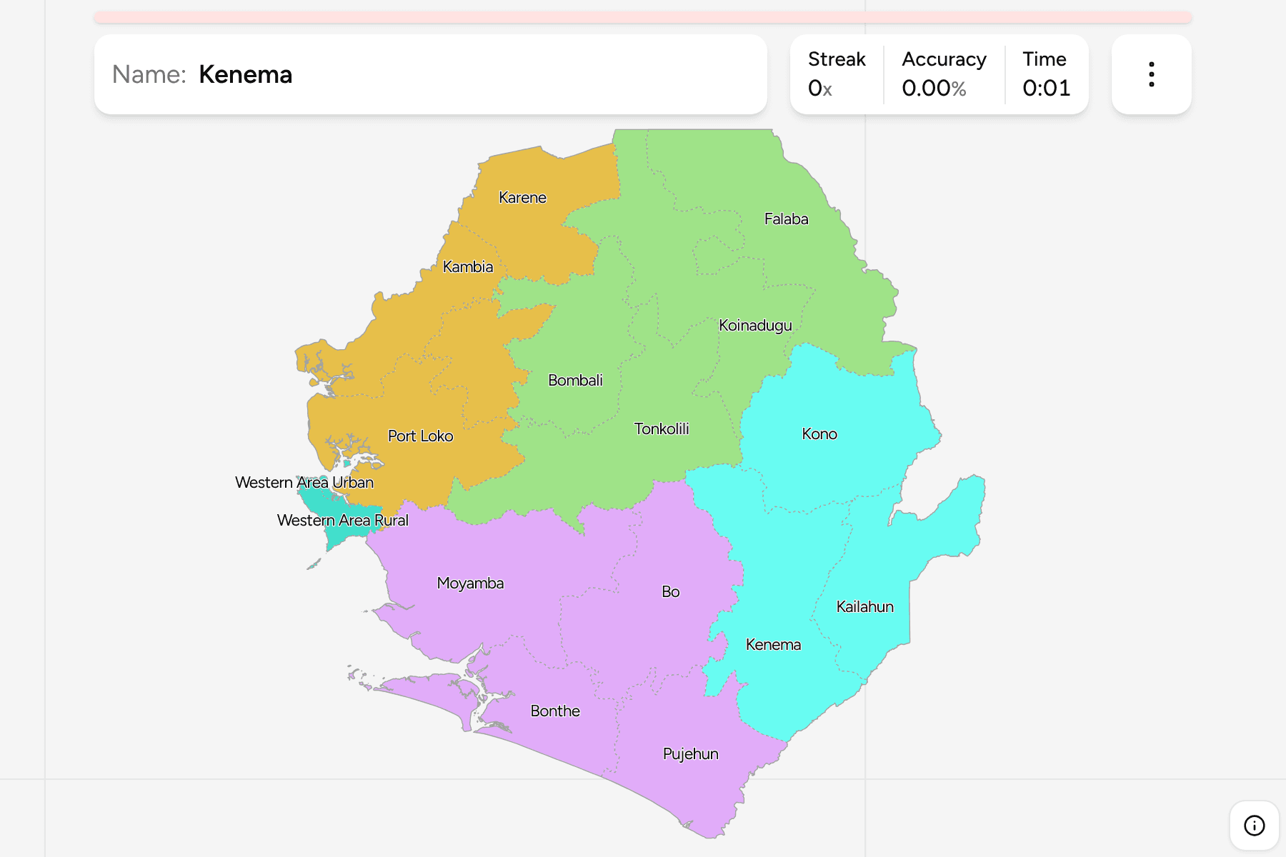
The districts as they stand: two in the Western Area around the capital,
Freetown, and the rest spread across the four provinces. The map includes the
districts made in 2017, Karene (out of Bombali) and Falaba (out of Koinadugu),
and the North Western province they brought the count of provinces to five
with. A map drawn before that has fourteen districts and four provinces.
The groups are the provinces. Western Area is drawn as a group of its own
because that is how the country counts it, even though it holds only two
districts.
How to place one
- Start with the peninsula. Western Area Urban is Freetown, a small
area on the tip of the Freetown peninsula, and Western Area Rural wraps
around it. They are the easiest pair to find and the hardest to hit.
- Learn the three borders. Guinea is to the north and east, Liberia to
the south-east, and the Atlantic to the south-west. The Northern and Eastern
districts reach the Guinea border, while Kailahun and Pujehun touch Liberia.
- Work down the coast. From the north: Kambia, Port Loko, Western Area,
Moyamba, Bonthe and Pujehun. Bonthe is the one with the islands, including
Sherbro Island.
- Look for the parent. Karene sits between Kambia and Bombali, and Falaba
in the north-east beside Koinadugu, which is the district it was split from.
Every district, by province
- Northern Province4 districts
- Bombali, Falaba, Koinadugu, Tonkolili
- Southern Province4 districts
- Bo, Bonthe, Moyamba, Pujehun
- Eastern Province3 districts
- Kailahun, Kenema, Kono
- North Western Province3 districts
- Kambia, Karene, Port Loko
- Western Area2 districts
- Western Area Rural, Western Area Urban
Worked examples
Western Area UrbanThe capitalWestern Area Urban is the smallest area on the map, on the north side of the
Freetown peninsula. Western Area Rural is the only district it touches by
land, and the Atlantic is on the other side.
BontheThe district with the islandsBonthe is a long strip of the southern coast, and it holds Sherbro Island and
a scatter of smaller ones. Its mainland is bordered by Moyamba and Pujehun.
FalabaA district from 2017Falaba is in the north-east corner on the border with Guinea, and it was
split from Koinadugu in 2017. Its neighbours are Koinadugu, Tonkolili and Bombali.
Frequently asked questions
How many districts does Sierra Leone have?
16 on this map. There were 14 until 2017, when Karene and Falaba were created.
How many provinces does Sierra Leone have?
Five. The Eastern, Northern, Southern and North Western provinces are drawn as groups here, and the Western Area, which holds the capital, is the fifth.
Is Freetown a district?
Freetown is the city, and it is the main part of Western Area Urban. Western Area Rural is the district around it.
For another country on the same coast, see Senegal Departments.
Sources