Tunisia is small, and that is what makes its governorates worth learning: the
whole country fits inside a day's driving, so the clue that places you is rarely
the landscape on its own. It is the governorate. Every road sign is bilingual,
every settlement is signposted by name, and the country changes from cork oak to
olive grove to steppe to desert over four hundred kilometres, with a governorate
boundary at each change. This page is all of them, the regions worth learning
them in, and what puts you inside one.
- The quiz
- Name to place, on the map
- Where it helps
- Road signs, landscape bands, coast versus interior
- In the game
- 24 governorates
What you are looking at
Tunisia is divided into 24 governorates, in Arabic wilayat, singular wilaya. The
governorate is the top tier of the country's administration and has been since
independence, with a governor appointed from Tunis; below it sit the delegations
(mutamadiyat), and below those the sectors. A governorate is named after its
capital in every single case, which is the most useful structural fact on this
page and the thing that makes the 24 learnable in an evening: if you know where
Kairouan is, you know where Kairouan governorate is.
The number that matters is 24, and a good deal of what is written about
Tunisia says 23. The country began with far fewer governorates at independence
and has split them repeatedly since: Sidi Bouzid in 1973, Siliana in 1974,
Zaghouan in 1976, Tozeur and Kébili in 1981, Ben Arous in 1983, Ariana out of
Tunis the same year, and finally Manouba out of Ariana in 2000. The 24 have been
stable ever since. Some widely used map data has not caught up, and the gap is
always the same one: the boundary file a great many atlases and quizzes are built
from has no Ariana at all, and hands its land to a hugely oversized Manouba.
Nothing on a Tunisian car tells you which governorate it is from, which is
the difference between Tunisia and both its neighbours. A civilian plate is a
national serial in two groups of digits with the Arabic word تونس between them,
where a Moroccan plate ends in a province number and an Algerian one ends in a
wilaya number. What names the governorate in Tunisia is officialdom on foot: the
sign outside the governorate's own building, the delegation office in every town,
and the wording on anything official you are handed.
How to place one
- Decide which of the four bands you are in. Tunisia runs north to south
through four landscapes and each is a few governorates deep. The far north is
the Tell: rolling, wet by North African standards, cork oak and wheat, with
real forest behind Aïn Draham. The Sahel is the eastern coastal strip from
Hammamet down past Sousse and Sfax, flat, densely built and planted with olive
trees in enormous regular grids. The centre west is the high steppe, open and
dry, with the country's mountains along the Algerian border. South of the
chotts everything is desert: palm oases, sand, and long empty roads.
- Then decide coast or interior. This is the split that does most of the
work on the map, because the governorates on the coast are small and the ones
behind them are large. The eastern coastline from Bizerte down to Sfax is
shared between eight of them; two cover most of the south on their own.
- Then read the sign. Tunisian direction signs carry Arabic and a French
transcription, in that order, on a blue or white ground. There is no Tifinagh
anywhere, which is the quickest way to tell a Tunisian sign from a Moroccan or
Algerian one. Road numbers help: A for the motorway spine down the coast, GP
or RN for the national roads, MC or RR for the regional ones.
- Then narrow inside the region. The seven groups below are three or four
governorates each, and each can be switched on and off on its own in the
game's start dialog, which is the fastest way to learn them.
The traps are mostly about size and mostly the same shape: a governorate much
smaller or much larger than its name suggests.
The capital is four governorates, not one. Tunis, Ariana, Ben Arous and
Manouba are a single continuous city of well over two million people, split four
ways for administration. Tunis governorate is the smallest in the country and is
essentially the old city, the port and the ancient sites along the bay: Carthage
and Sidi Bou Saïd are both in it. Ariana is the northern suburbs and the farmland
behind them, Ben Arous the southern industrial belt, and Manouba the western
approach out towards the plain.
Two governorates are two fifths of the country. Tataouine alone is about a
quarter of Tunisia's land area and Kébili another seventh, and between them they
hold under three percent of its population. Anywhere genuinely empty in the south
is one of those two, and the split is roughly the Dahar escarpment: west of it
and you are in Kébili, east and south of it and you are in Tataouine.
Djerba is not a governorate. The island is part of Médenine, along with
Zarzis and the mainland behind it, which surprises people who expect somewhere
that famous to have its own name on the map.
The chotts divide the south, not a line of latitude. Chott el Djerid, the
salt flat the causeway crosses, is the boundary between the south west (Tozeur,
Kébili, Gafsa) and everything east of it. If you have just driven across white
crusted salt, you have changed governorate.
Every governorate, by region
- Grand Tunis4 governorates
- Tunis, Ariana, Ben Arous, Manouba
- North West4 governorates
- Béja, Jendouba, El Kef, Siliana
- North East3 governorates
- Nabeul, Zaghouan, Bizerte
- Centre West3 governorates
- Kairouan, Kasserine, Sidi Bouzid
- Centre East4 governorates
- Sousse, Monastir, Mahdia, Sfax
- South East3 governorates
- Gabès, Médenine, Tataouine
- South West3 governorates
- Gafsa, Tozeur, Kébili
Those seven groups are Tunisia's own. They are the development regions the
national statistics office reports in, so the census, the household survey and
every regional figure the country publishes come out cut this way. They are also
plain geography, which is why they are worth drilling: each one is a landscape as
well as an administrative convenience.
Grand Tunis is the capital's four governorates, which were one until 1983.
The North West is the Tell, the wettest and greenest part of the country,
with the Algerian border along its far side. The North East is Bizerte, Cap
Bon and Zaghouan behind them, which is coast, vineyards and the country's
northernmost point. The Centre West is the high steppe, the poorest region by
most measures and the one where the 2011 revolution began, at Sidi Bouzid. The
Centre East is the Sahel, the olive coast, and holds Sousse, Monastir, Mahdia
and Sfax, which is the second city and the country's industrial engine. The
South East is the Gulf of Gabès, Djerba and the desert behind them out to the
Libyan border. The South West is the oases: Tozeur, Nefta, Douz and the
chotts between them.
Worked examples
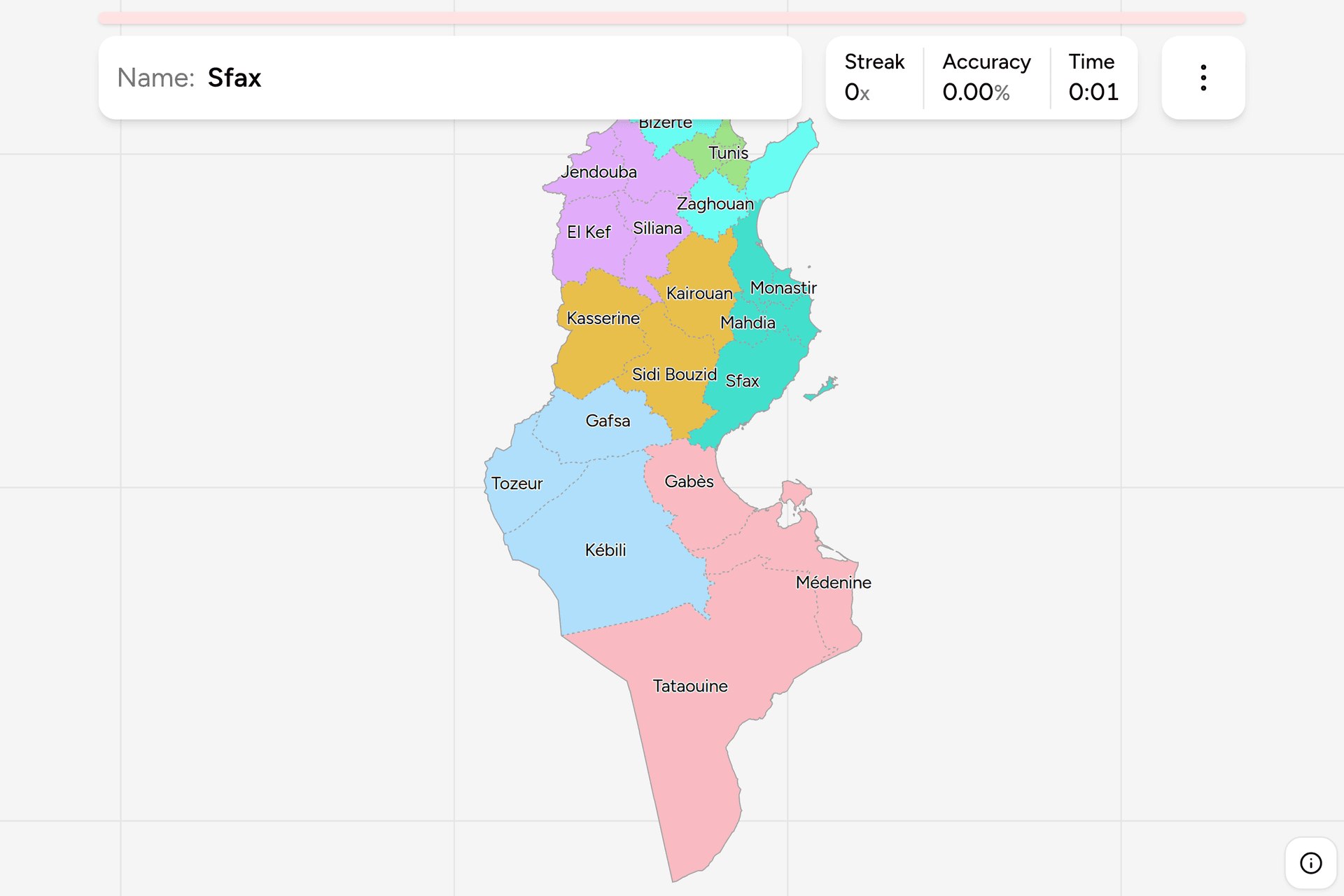
TataouineThe one that is a quarter of the countryTataouine: everything in the south east corner, from the Dahar escarpment down
to the Libyan and Algerian borders, and it is much the largest of the 24. It is
also nearly empty, so almost anything you see from a road here is either the
ksour, the fortified granaries of the Dahar with their stacked barrel-vaulted
cells, or open hamada. If you have been driving through nothing for an hour in
southern Tunisia and the ground is stony rather than sandy, this is where you
are.
ArianaThe one most maps are missingAriana: the northern half of greater Tunis, split off from Tunis governorate in
1983 and holding the northern suburbs, the university quarter and the farmland
behind them out to the Sebkhet Ariana. It is the second smallest of the 24 and
it is
the one to check any Tunisia map against, because a boundary file that has 23
governorates is a boundary file that has left this one out and given its land
to Manouba.
SfaxThe big one on the coastSfax: the second city and the largest governorate on the Sahel coast, running
a long way inland and taking in the Kerkennah Islands offshore. Everything
about it is olives and industry: the olive groves south and west of the city
are among the largest continuous plantings anywhere, in a spacing regular
enough to recognise from the road, and the city itself is a working port with a
walled medina in the middle of it. It is the easy answer once you have found
the coast, because it is the only large governorate that touches the sea
between Mahdia and Gabès.
Frequently asked questions
How many governorates does Tunisia have?
24, and it has had 24 since 2000, when Manouba was split off from Ariana. The governorate is the top administrative tier, is run by a governor appointed by the central government, and is divided into delegations below. Sources that give 23 are usually working from a boundary dataset that has never carried Ariana, which was created out of Tunis governorate in 1983.
Are Tunisian governorates named after cities?
Yes, every one of them, without exception. Each governorate takes the name of its capital, so the 24 names are 24 towns. That is what makes them quicker to learn than most administrative divisions: placing the town places the governorate, and there is no equivalent of a region named after a river or a compass direction to catch you out.
Do Tunisian number plates show the governorate?
No. A Tunisian civilian plate is a national serial number in two groups with the Arabic word for Tunisia between them, and it encodes nothing about where the car is registered. That is a real difference from the countries either side, since Morocco puts a province number on the plate and Algeria puts a wilaya number. What names the governorate in Tunisia is official signage and paperwork rather than anything on a vehicle.
What languages are on Tunisian road signs?
Arabic and French, usually with Arabic first or above. French is not an official language but is used on signage, in business and in a great deal of public life, and the transcriptions on signs follow French spelling conventions. There is no Tifinagh on Tunisian signs, which is a quick way to tell Tunisia from Morocco or parts of Algeria, where the Amazigh alphabet appears on newer signage.
What are the seven regions of Tunisia?
Grand Tunis, the North East, the North West, the Centre East, the Centre West, the South East and the South West. They are development regions rather than a tier of government, which means they have no governor and no council, but they are the cut the national statistics office publishes everything in, from the census to regional unemployment, and they map onto the country's landscapes closely enough to be worth learning as geography.
Which is the largest governorate of Tunisia, and which the smallest?
Tataouine in the far south is much the largest, at roughly a quarter of the country's land area, followed by Kébili. Tunis is the smallest, and three of the four smallest are the greater Tunis governorates of Tunis, Ariana and Ben Arous. By population the order is close to reversed: greater Tunis holds well over two million people and Tataouine around two hundred thousand.
Which Tunisian governorates are easiest to confuse?
The four in greater Tunis, because they are one city and the boundaries between them are invisible on the ground. The Sahel strip of Sousse, Monastir and Mahdia, which are stacked down the same coast in the same landscape. And the pairs on either side of the chotts, since Tozeur, Kébili and Gafsa all look like oasis country and are told apart mainly by which side of Chott el Djerid you are on.
Is Djerba its own governorate?
No. Djerba is part of Médenine governorate, which also covers Zarzis, the Jorf peninsula and the mainland behind them. The island is divided into three delegations, Houmt Souk, Midoun and Ajim, but a delegation is the tier below a governorate, so on this map the whole island answers to Médenine.
The other African trainers here are Egypt Governorates,
Morocco Regions, Kenya Counties, Nigeria
States, South Africa Provinces and
South Africa Dialing Codes. For administrative
maps of a similar size, try Japan Prefectures, Spain
Provinces and Italy Regions.
Sources
- Governorates of Tunisia, the 24 governorates, their capitals, and the splits that created them
- Delegations of Tunisia, the tier below, which is what a local sign outside a town hall names
- Institut National de la Statistique, the seven development regions, and the figures published by them
- Vehicle registration plates of Tunisia, the plate format, and why it places the country and not the governorate
- geoBoundaries, the governorate boundaries this game's map is built from, drawn from OpenStreetMap