Egypt does not write the governorate on its number plates in any form you can
read, so the name in a round comes off a road sign, a government building or the
landscape itself. That leaves the hard half of the question: where is that
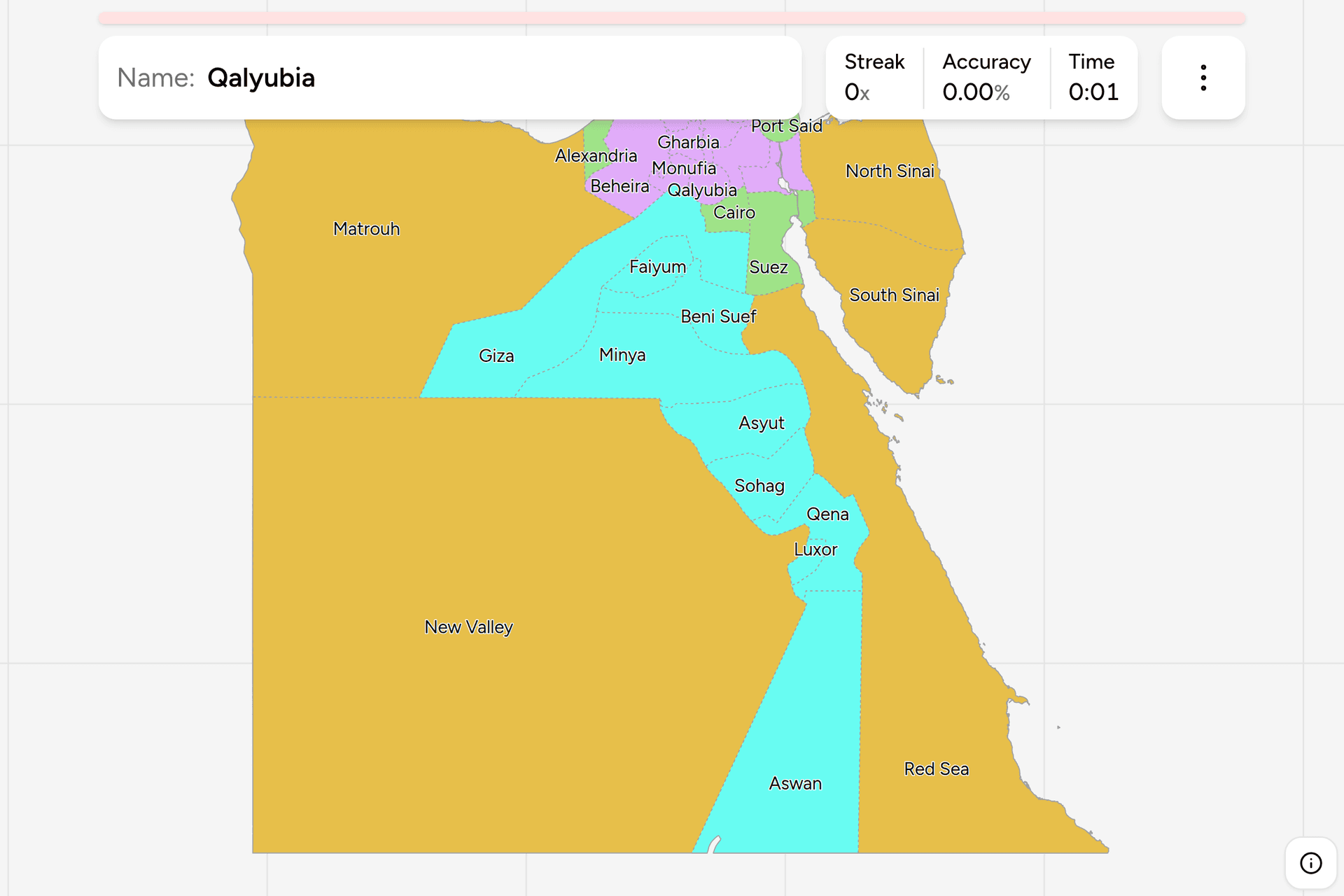
governorate? This page is all 27 of them, grouped the way Egypt's own statistics
group them, and the game asks you to put each name on the map.
- The quiz
- Name to place, on the map
- Where it helps
- Town names on signs, the Nile, the desert roads
- In the game
- 27 governorates
What you are looking at
Egypt is run as governorates, muhafazat in Arabic, each under a governor the
president appoints rather than one anybody elects. There have been 27 since 2011,
when two short-lived ones were folded back into Cairo and Giza, and the newest of
them is Luxor, split off from Qena in 2009.
The map they make is the strangest in this catalogue, and the reason is the one
fact everybody already knows about Egypt. Almost the whole population lives on
the Nile and in its Delta, which is a few per cent of the country, so the
governorates that hold nearly all the people are the small ones crowded into the
north and along the river, and the four that hold almost nobody are enormous.
New Valley alone is bigger than every Delta governorate put together, several
times over.
Learning the names is unusually cheap here, because most of them are not proper
names at all. A governorate is normally called after its capital, so the town on
the sign in front of you is often the answer: Damietta, Aswan, Asyut, Sohag,
Qena, Minya, Beni Suef, Faiyum, Luxor, Ismailia, Port Said and Suez all work that
way. Most of the rest are plain Arabic descriptions of where they are, which is
worth knowing even if you do not read the script: Gharbia is "the western one",
Sharqia "the eastern one", Beheira "the lake", the Red Sea and the New Valley say
what they are, and North and South Sinai need no translating at all.
Turn on the local name in the start dialog and the game asks in Arabic instead,
which is the form on every sign, plate and ministry board in the country. The
word you will see missing from each of them is muhafazat, the "governorate" a
sign usually puts in front: the map labels the name itself, the way its English
labels say Cairo rather than Cairo Governorate.
How to place one
- Find the water first. Egypt is three landscapes and the answer is in a
different place in each. The Delta is flat, green, dense and cut by canals in
every direction, with towns running into each other. The valley is a green
strip between two desert walls, rarely more than fifteen kilometres wide, with
the cliffs visible from almost anywhere in it. Everything else is desert, and
desert means one of four names before you have looked at anything else.
- Then work out which side of Cairo you are on. This is the single most
common mistake on this map, and it is a vocabulary problem rather than a
geography one. Upper Egypt is the south and Lower Egypt is the north, because
the names are the river's and the Nile flows north. Sailing up the Nile is
sailing towards Aswan.
- In the valley, count. South of Cairo the governorates are a single file
along the river in a fixed order: Giza, then Beni Suef, Minya, Asyut, Sohag,
Qena, Luxor and Aswan, with Faiyum off to the west in its own depression. Each
one is a band across the valley, so any town name that places you on the river
places you in the sequence, and the sequence does the rest.
- In the Delta, use the branches and the coast. The Nile splits at Cairo
into the Rosetta branch in the west and the Damietta branch in the east.
Beheira is west of the western branch and Sharqia east of the eastern one,
with Monufia, Gharbia, Qalyubia and Dakahlia filling the middle. Alexandria,
Kafr el-Sheikh, Damietta and Port Said take the coast from west to east.
- On the canal and in the desert, one landmark is enough. Port Said,
Ismailia and Suez sit at the north end, the middle and the south end of the
Suez Canal in that order. Sinai divides north and south at roughly the middle
of the peninsula. The Red Sea governorate is the whole western shore of its
sea, Matrouh is the whole Mediterranean coast west of Alexandria, and the New
Valley is everything else in the south west.
The traps are almost all names, and there are three kinds.
Capitals that are not their governorate's namesake. Tanta is in Gharbia,
Zagazig in Sharqia, Mansoura in Dakahlia, Banha in Qalyubia, Shibin el-Kom in
Monufia and Damanhur in Beheira. In the desert it happens again: Hurghada is the
capital of the Red Sea, Kharga of the New Valley, Arish of North Sinai and Marsa
Matrouh of Matrouh. Six of the nine Delta governorates and four of the five
frontier ones are named after something other than their biggest town, and the
Delta six are exactly the ones whose names are directions instead.
The famous place that is in the next governorate along. The pyramids are in
Giza and not Cairo, which is the one everybody gets wrong. Sharm el-Sheikh and
Dahab are in South Sinai, whose capital is the much quieter el-Tor. Marsa Alam is
in the Red Sea governorate, hundreds of kilometres south of Hurghada. Siwa is in
Matrouh, five hundred kilometres from the sea the governorate is named for. Abu
Simbel is in Aswan, almost on the Sudanese border.
Names that start the same way. Beni Suef and Beheira, Qena and Qalyubia,
Sohag and Suez, Minya and Monufia: in each pair one is in the Delta and the other
in the valley or on the canal, which is the fastest way to keep them apart.
Every governorate, by region
- Urban4 governorates
- Alexandria, Cairo, Port Said, Suez
- Lower Egypt9 governorates
- Beheira, Dakahlia, Damietta, Gharbia, Ismailia, Qalyubia, Kafr el-Sheikh, Monufia, Sharqia
- Upper Egypt9 governorates
- Aswan, Asyut, Beni Suef, Faiyum, Giza, Qena, Luxor, Minya, Sohag
- Frontier5 governorates
- Red Sea, South Sinai, Matrouh, North Sinai, New Valley
Those four are how Egypt reports itself. The census, the labour force survey, the
health survey and the budget are all published against them, which makes this the
one grouping an Egyptian reader would recognise without being told. Each can be
switched on and off on its own in the game's start dialog, so the frontier is a
five governorate drill and the urban four are a four.
Two of the four need a note. Urban is not a size category: those are the
governorates that are only a city, with no rural districts under them at all,
which is why Suez is in it and much larger Damietta is not. Frontier is the
other four fifths of Egypt, five governorates holding a couple of per cent of the
population between them, and it is the group to drill first: they are enormous,
they have unmistakable shapes, and getting them right leaves the whole of the
crowded part of the map as the only thing left to learn.
Worked examples
GizaThe one everybody puts in the wrong placeGiza: the Pyramids, the Sphinx and Saqqara are all here rather than in Cairo,
which is the governorate on the other bank. On the map it is the wedge running
west from the Nile opposite Cairo and then far out into the Western Desert, so
it is both a crowded suburb of the capital and an empty quarter of the Sahara.
Its plates are the one Egyptian giveaway of this kind: Giza issues two letters
where every other governorate issues three.
LuxorThe newest, and one of the smallestLuxor: a short stretch of the valley around the ancient city, cut out of Qena
in 2009 to run the tourism on its own. On the map it is the small block between
Qena above it and Aswan below, and it is the target here you are most likely to
miss by tapping rather than by not knowing, so zoom in before you commit.
Everything a round is likely to show you of it, the Valley of the Kings, Karnak
and the corniche, is within a few kilometres of the river.
New ValleyThe big empty oneNew Valley: the largest governorate in Egypt by a very wide margin, filling the
entire south west of the country, and home to well under one per cent of its
people. What is in it is the string of oases, Kharga, Dakhla and Farafra, and
the roads between them. If a round drops you on a desert highway with nothing
but sand, escarpment and the occasional palm plantation, and you are anywhere
south or west of Faiyum, this is the safest name on the map.
Frequently asked questions
How many governorates does Egypt have?
27. The number has been steady since 2011, when Helwan and 6th of October were abolished and their land went back to Cairo and Giza. The newest one still standing is Luxor, separated from Qena in 2009. Each is run by a governor appointed by the president, and Egypt's own statistics sort the 27 into four groups: the urban governorates, Lower Egypt, Upper Egypt and the frontier.
What is the difference between Upper and Lower Egypt?
Upper Egypt is the south and Lower Egypt is the north, which catches out almost everybody the first time. The names are the river's rather than the map's: the Nile rises in the south and flows north to the Mediterranean, so upstream is upper. Lower Egypt is the Delta, Upper Egypt is the valley from Giza south to Aswan, and the two have been named this way since the pharaohs.
Do Egyptian number plates show the governorate?
Not in a form you can read off as a name. The current plate, in use since 2008, carries Egypt in Arabic and English along the top and then Arabic numerals and letters, and the letters encode the traffic department that issued it rather than spelling anything out. Two counts do give something away: Cairo issues three digits where everywhere else issues four, and Giza issues two letters where everywhere else issues three. Beyond those, the plate tells you the country and the vehicle class, and the governorate has to come from a sign.
Which governorate are the pyramids in?
Giza, not Cairo. The Giza plateau is on the west bank of the Nile and Cairo governorate is on the east, so the pyramids, the Sphinx and the older step pyramid at Saqqara are all in Giza. Giza also runs west into the Western Desert for hundreds of kilometres, which makes it one of the larger governorates as well as one of the most crowded.
Which is the largest governorate in Egypt, and which the smallest?
New Valley is the largest by a long way, covering the south west of the country and roughly two fifths of Egypt on its own, with the Red Sea and Matrouh next. Damietta, on the coast at the eastern mouth of the Nile, is the smallest. Population runs the other way: the frontier governorates together hold a couple of per cent of Egyptians, while Cairo and Giza between them hold something closer to a fifth.
Which governorates are on the Suez Canal?
Three, in order from the Mediterranean to the Red Sea: Port Said at the northern entrance, Ismailia in the middle where the canal meets Lake Timsah, and Suez at the southern end. Two of the three are urban governorates, and Ismailia is counted with Lower Egypt. North and South Sinai are across the canal to the east, which is the boundary between Africa and Asia running through the middle of the map.
What is a governorate in Egypt?
The top tier of local government, called a muhafazah in Arabic. A governor is appointed by the president and runs it, and most governorates are divided further into markaz districts, each with a town at its centre. The four urban governorates are the exception: Cairo, Alexandria, Port Said and Suez are cities governed as governorates, with no rural districts under them, which is what puts them in a class of their own rather than their size.
The other African trainers here are Kenya Counties, Nigeria
States, South Africa Provinces and
South Africa Dialing Codes. For administrative
maps that work the same way, try Turkey Provinces, India
States and Spain Provinces.
Sources