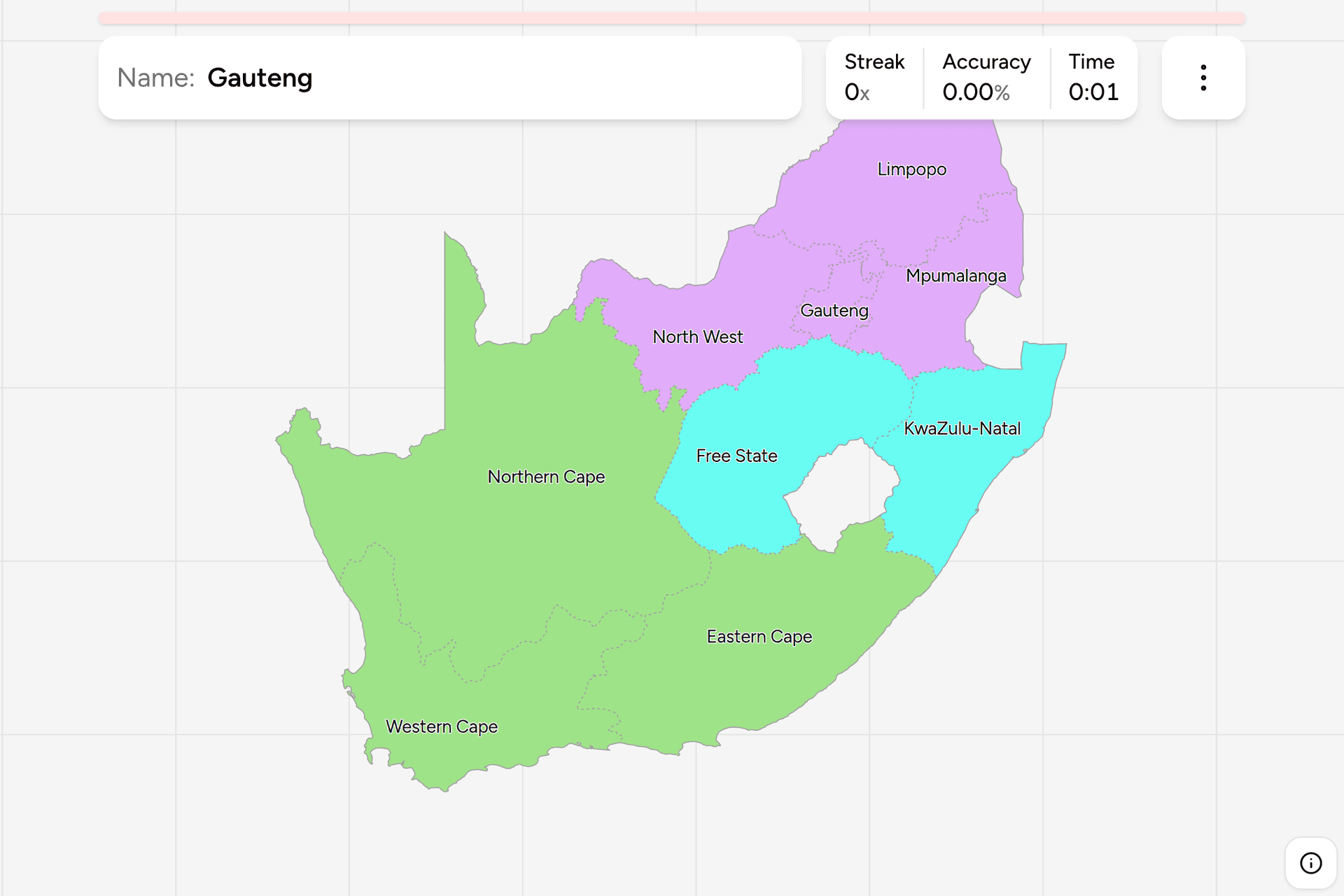
South Africa's nine provinces are unusually easy to read off a photograph,
because almost every car on the road carries the name of one on its number
plate. Learn the nine and you have a country-sized clue that works on a farm
road as well as in a city, and a frame to hang the language, the vegetation and
the mountains on. This page is the whole set, and the game asks you to put each
name where it belongs.
- The quiz
- Name to place, on the map
- Best clue on the ground
- The number plate
- In the game
- 9 provinces
What you are looking at
The nine provinces are young. Until 27 April 1994 South Africa was divided into
four provinces, the Cape Province, Natal, the Orange Free State and the
Transvaal, alongside ten nominally independent or self-governing homelands
carved out of them. The 1994 constitution dissolved the homelands, folded them
back into the country and re-cut the whole thing into nine, which is why several
of the provinces have a shape that only makes sense once you know a homeland
used to sit inside it. Two of the nine changed their names afterwards: the
Northern Transvaal became the Northern Province and then Limpopo in 2003, and
the PWV, for Pretoria, Witwatersrand and Vereeniging, became Gauteng at the end
of 1994.
Each province has an elected legislature and a premier, and each has its own
capital, which is often not its largest city. Bhisho runs the Eastern Cape while
Gqeberha and East London are the cities in it, and Pietermaritzburg runs
KwaZulu-Natal from an hour inland of Durban. Only Cape Town, Johannesburg,
Bloemfontein, Kimberley and Polokwane are both the capital and the obvious
centre of the province they govern.
What makes the set worth learning is that provincial borders are the strongest
administrative boundary in the country and one of the few things about a South
African road that changes when you cross one. The road signs, the markings, the
bollards and the guardrails are national. The number plate is not.
How to place one
- Read the number plate first. Seven of the nine use a format that ends in
the province: three letters, three digits, then
GP for Gauteng, FS for
the Free State, EC for the Eastern Cape, NC for the Northern Cape, NW
for the North West, MP for Mpumalanga and a lone L for Limpopo. That is
the answer handed to you.
- If the plate has no suffix, it is one of two. The Western Cape and
KwaZulu-Natal kept the older system, where the letters at the front are a
town rather than a province and the digits follow after a dash. Every Western
Cape code begins with C and every KwaZulu-Natal code begins with N,
so
CA 123-456 is Cape Town and ND 123-456 is Durban. One letter separates
the two ends of the country.
- Then listen to the signage. The language on a school, a clinic or a
spaza shop follows the province closely: isiXhosa in the Eastern Cape,
isiZulu in KwaZulu-Natal, Sesotho in the Free State, Setswana in the North
West, siSwati in Mpumalanga, Sepedi in Limpopo, and Afrikaans across the
Western and Northern Cape. Gauteng is the one that reads as everything at
once.
- Then the landscape, which splits the country in three. Winter rainfall,
fynbos and folded mountains mean the Western Cape. Red sand, quiver trees and
nothing for an hour mean the Northern Cape. Summer rainfall over open
grassland is the interior plateau, and the plateau is where the plate matters
most, because the Free State, the North West and Gauteng look alike from a
car.
The failure modes are all names. North West is not the northwest of the
country, the Northern Cape is further west and Limpopo is further north. It is
the block west of Gauteng, and it takes its name from being the northwestern
quarter of the old Transvaal. Northern Cape is not northern either, it is
the whole dry western third and it reaches further south than Gauteng does.
And Mpumalanga and Limpopo are the two most swapped, both being lowveld
provinces on the Mozambique side with a piece of the Kruger Park each. Limpopo
is the top one, against Zimbabwe and named for the river that forms the border.
Mpumalanga sits under it, and its name means "the place where the sun rises",
which is the right way round if you remember it is the east rather than the
north.
Every province, by where it came from
- The old Cape Province3 provinces
- Western Cape, Northern Cape, Eastern Cape
- The old Transvaal4 provinces
- Gauteng, North West, Mpumalanga, Limpopo
- Natal and the Free State2 provinces
- KwaZulu-Natal, Free State
Those three groups are the four provinces of 1910 with the homelands folded back
in, and they are still legible in the names: three carry the word Cape, one
carries Natal, one is the Free State by the name it always had, and the four
that are left are the old Transvaal cut into quarters, with a strip of the
northern Cape Province added to the North West. The map in the game is coloured
the same way, so the three blocks are visible while you play, and each can be
played on its own from the start dialog.
Worked examples
Northern CapeThe default guess for anywhere emptyNearly a third of the country by area and about two percent of its people. If
a road runs dead straight between red dunes or grey Karoo scrub with a
windpump on the horizon and no town for fifty kilometres, this is the odds-on
answer. It also reaches much further south than the name suggests, down to the
Karoo towns north of the Cape Fold Mountains, so a dry inland scene well south
of Kimberley is still likely to be this one.
GautengThe smallest, and the one you will land in mostThe smallest province by a wide margin and the largest by population, holding
Johannesburg, Pretoria and most of the country's coverage. Give it away by the
mine dumps, flat-topped pale yellow hills of sand left by the gold reef, and
by the toll gantries that stand over the freeway every few kilometres, which
exist nowhere else in the country.
North WestThe one the name misplacesNot the northwestern corner of South Africa, which belongs to the Northern
Cape. This is the bushveld and platinum belt directly west of Gauteng, running
from the Magaliesberg out to the Botswana border at Vryburg and Mahikeng. It
is named for the part of the Transvaal it was cut from rather than for where
it sits, and it is the province most often clicked in the wrong place on this
map.
Eastern CapeThe one with two halvesWestern half: dry Karoo, sheep and Afrikaans, continuous with the Northern
Cape next door. Eastern half: green rolling hills covered in scattered
homesteads and round huts, and isiXhosa on every sign, which is the former
Transkei. Those hillsides of small houses spread evenly across the grass with
no village between them are one of the most recognisable scenes in the
country, and they are almost always this province or the KwaZulu-Natal side of
the same belt.
Frequently asked questions
How many provinces does South Africa have?
Nine, since 27 April 1994. They are the Eastern Cape, the Free State, Gauteng, KwaZulu-Natal, Limpopo, Mpumalanga, the North West, the Northern Cape and the Western Cape. Before that there were four provinces and ten homelands, and the nine were drawn by merging the two sets together and re-cutting them.
What were the provinces of South Africa before 1994?
Four: the Cape Province, Natal, the Orange Free State and the Transvaal, which had been the four since the Union of 1910. Alongside them sat ten homelands, four of which had been declared independent states that no country other than South Africa recognised. The 1994 constitution abolished all of that and replaced it with the current nine.
What is the largest province in South Africa?
The Northern Cape by area, at about 372,000 square kilometres, which is close to a third of the country and larger than Germany. It is also the least populated, with roughly one and a quarter million people. Gauteng is the reverse on both counts: the smallest by area and by far the largest by population.
How can you tell which South African province a photo is in?
The number plate. Seven provinces use a plate that ends in a two letter provincial code, GP, FS, EC, NC, NW or MP, or a single L for Limpopo. The Western Cape and KwaZulu-Natal use an older town based system instead, where the code comes first and always starts with C in the Western Cape and N in KwaZulu-Natal. Failing a plate, the language on local signage tracks the province closely.
What are the capitals of the South African provinces?
Cape Town for the Western Cape, Kimberley for the Northern Cape, Bhisho for the Eastern Cape, Bloemfontein for the Free State, Pietermaritzburg for KwaZulu-Natal, Johannesburg for Gauteng, Mahikeng for the North West, Mbombela for Mpumalanga and Polokwane for Limpopo. Several are not the largest city in their province, which is why they are worth learning separately from the map.
Why is Limpopo called Limpopo?
It is named after the river that forms the border with Zimbabwe and Botswana along its northern edge. The province was the Northern Transvaal until 1994, then the Northern Province, and took the river's name in 2003 after several years of argument about what to call it. Mpumalanga next door was the Eastern Transvaal and was renamed in 1995.
Which South African provinces are easiest to confuse?
The North West and the Northern Cape, because the names both point at a corner and only one of them is right: the North West is the block beside Gauteng and the Northern Cape is the whole dry west. And Mpumalanga against Limpopo, which are the two lowveld provinces stacked one above the other on the eastern border, with Limpopo on top against Zimbabwe.
The other South African map is built on the same country: South Africa Dialing
Codes, whose blocks were drawn around the old
telephone regions rather than these provinces, which is why the two maps
disagree. More administrative maps in the same shape: Germany
States, Poland Voivodeships and India
States.
Sources