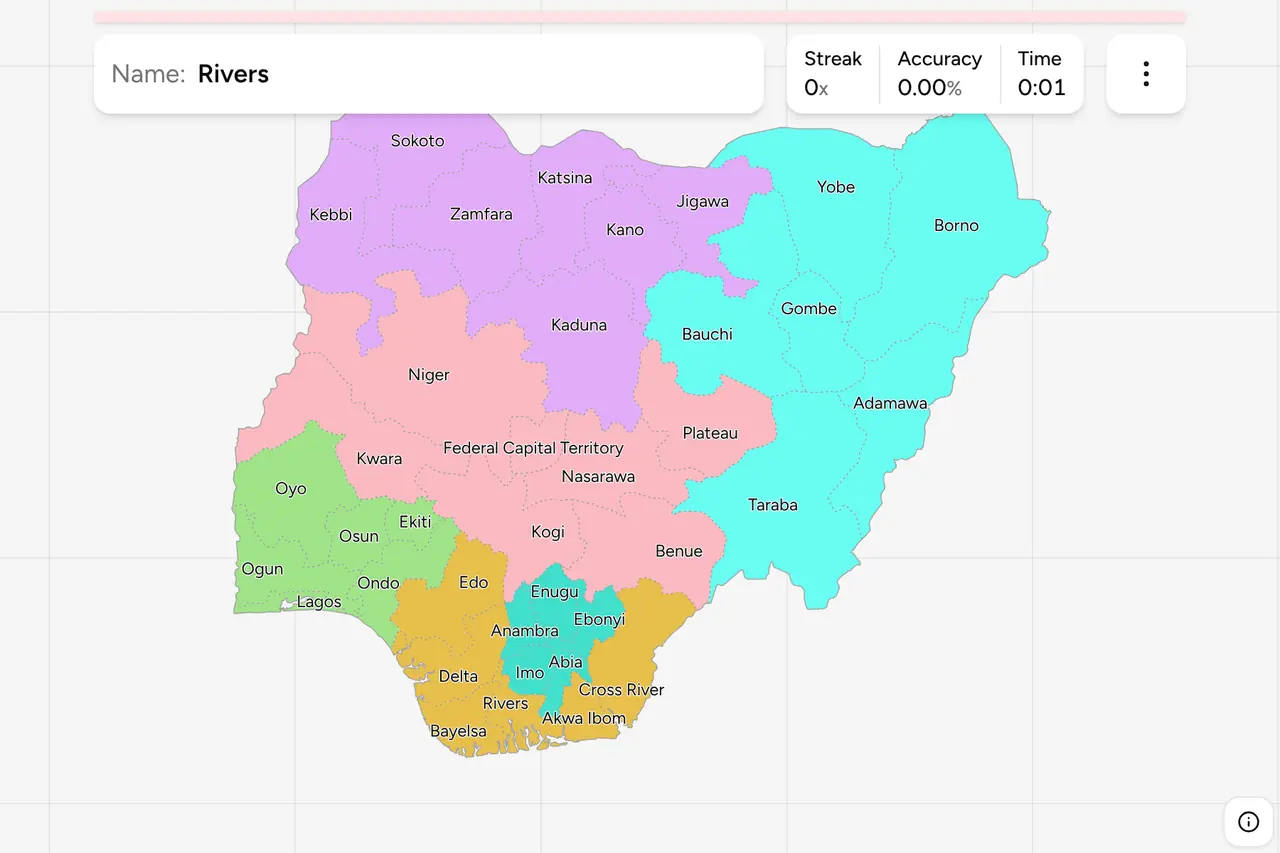
Nigeria writes the answer on the back of its cars. Every Nigerian plate carries
the state it was registered in, spelled out in words along the bottom edge, so a
vehicle in shot hands you the state and leaves you one question: where is that
state? This page is the whole set, zone by zone, and the game asks you to put
each name on the map.
- The quiz
- Name to place, on the map
- Where it helps
- Plates, road signs, boundary signs
- In the game
- 37 states
What you are looking at
Nigeria is a federation of 36 states and one federal capital territory, and
unlike most administrative maps this one is only thirty years old. The country
began independence in 1960 with three regions, split into twelve states in 1967,
and then split again in 1976, 1987, 1991 and finally 1996, which is when the
present 36 were fixed. Nothing has moved since. That history is why the shapes
are blocky and why so many of the names are unfamiliar even to people who know
the country: seventeen of the thirty-seven were created in 1987 or later, which
makes them younger than a good share of the people driving through them.
The Federal Capital Territory is the odd one out and Nigerians are precise about
it. It is not a state, it has no governor, and it exists because the capital was
moved out of Lagos: the territory was carved out of the middle of the country in
1976 and Abuja formally took over as capital in 1991. On the map it is the small
wedge in the geographic centre, wrapped by Niger, Kaduna, Nasarawa and Kogi.
The plate is the clue. A modern Nigerian plate is white with a blue strip at
the top reading FEDERAL REPUBLIC OF NIGERIA, a registration in the middle in the
form ABC-123DE, and the state's name along the bottom, usually beside that
state's slogan. Lagos plates say Centre of Excellence, Benue plates say Food
Basket of the Nation, Kogi plates say The Confluence State, and Abuja plates say
Centre of Unity. You do not need the slogans: the state name is written there in
full. What you need is the map, and that is the whole reason this trainer
exists. The three letters at the front of the registration encode a local
government area rather than the state, so they are more precise and much harder
to read without a table.
The other place the name is written is the road. Nigerian signs are in English,
and a boundary sign welcomes you to the state you are entering by name, often
with the same slogan underneath.
How to place one
- Get the latitude from the vegetation. Nigeria runs from mangrove and oil
palm on the Niger Delta coast to open Sahel scrub on the Niger border, over
about a thousand kilometres, and the gradient is continuous. Dense green,
palms and standing water put you in the far south. Tall grass with scattered
broad trees is the middle belt. Sparse thorn, sand and long views put you in
the far north.
- Then get the longitude from the language on the signage. The south west
is Yoruba, the south east is Igbo, and the north is Hausa, with Arabic script
appearing on signs and shopfronts as you go further north. English is
official everywhere and is what most road signs use, so this is about the
second language rather than the first.
- Then narrow inside the zone. The six zones below are the shape most
Nigerians carry in their head, and each is small enough to work through: five
states in the South East, six in the North East, seven in the North West.
Getting the zone right is most of the score.
The traps are mostly names. Niger is a state in the middle of the country,
the country to the north, and the river that runs through both, and only one of
those three is being asked for here. Kogi and Kwara sit next to each
other in the middle belt and are easy to swap. There are six states beginning
with K: Kano, Katsina and Kaduna are neighbours in the north west, Kebbi is off
to the west on the Benin border, and Kogi and Kwara are in the North Central. The
South West has four states beginning with O (Ogun, Ondo, Osun, Oyo) packed into
one corner, plus Ekiti and Lagos.
Several states are named after their largest city, which is a useful shortcut
where it holds: Kano, Katsina, Sokoto, Kaduna, Bauchi, Gombe and Enugu are all
states whose capital is the city of the same name. It does not hold everywhere,
so do not lean on it. Oyo state is run from Ibadan, Ondo from Akure, Abia from
Umuahia and Lagos state from Ikeja, and in each of those the city you have heard
of is not the state's namesake or not its capital.
Every state, by zone
- South West6 states
- Ekiti, Lagos, Ogun, Ondo, Osun, Oyo
- North West7 states
- Jigawa, Kaduna, Kebbi, Kano, Katsina, Sokoto, Zamfara
- North East6 states
- Adamawa, Bauchi, Borno, Gombe, Taraba, Yobe
- South South6 states
- Akwa Ibom, Bayelsa, Cross River, Delta, Edo, Rivers
- South East5 states
- Abia, Anambra, Ebonyi, Enugu, Imo
- North Central7 states
- Benue, Federal Capital Territory, Kogi, Kwara, Nasarawa, Niger, Plateau
Those are the six geopolitical zones. They were drawn in the mid 1990s and they
have no constitutional standing at all: no governor, no assembly, no budget. What
they have is everything else. Federal appointments are balanced across them,
party tickets are zoned between them, election results are read out by them, and
a Nigerian describing where somebody is from will very often name the zone
before the state. They are the grouping worth learning first, and each can be
switched on and off on its own in the game's start dialog, which makes the South
East a five state drill and the North East an evening.
Two of the six names surprise people. South South is not a typo: it is the
Niger Delta, the oil producing coast that runs from Edo round to Cross River,
and its name is a compromise, because unlike the South East and the South West
the region has no single people to be named after. North Central is the
middle belt, and it is the zone that carries the Federal Capital Territory,
which is why it has seven members while the two other northern zones have six
and seven states of their own.
Worked examples
LagosThe small one everybody has heard ofThe smallest state on this map and the one with the most people in it: a
coastal strip in the far south west, wrapped around a lagoon, with the
Republic of Benin a few kilometres to the west. It is the only state you might
reasonably fail to click rather than fail to name, so zoom in before you tap.
Lagos was the federal capital until 1991 and the plates still say Centre of
Excellence.
Federal Capital TerritoryThe one that is not a stateThe Federal Capital Territory, the wedge in the middle of the country that
holds Abuja. It was cut out of the surrounding states in 1976 precisely
because it belonged to none of them, which is the same reason it is the
hardest target here to place from memory: there is no city, river or coast
attached to it that you would recognise from the outside. Find the geographic
centre of the country and it is the small shape just south west of it.
BornoThe big one in the cornerOne of the two largest states by area, and the one in the far north east
corner, against Lake Chad, Niger, Chad and Cameroon. Sahel country: thorn
scrub, sand and long flat horizons, nothing like the south. Borno is worth knowing as a shape rather
than a name, because it is the one state on this map you can identify from the
outline alone, and because anything that looks that dry is either Borno or its
neighbour Yobe.
Frequently asked questions
How many states does Nigeria have?
36, plus the Federal Capital Territory, which is not a state and is usually counted separately. The present set was fixed in 1996 and has not changed since. They are conventionally grouped into six geopolitical zones, and the game lets you drill one zone at a time.
What are the six geopolitical zones of Nigeria?
North West, North East, North Central, South West, South East and South South. They were drawn in the mid 1990s and have no constitutional status, but federal appointments, party tickets and election results are all balanced and reported across them, so they are the grouping Nigerians actually use. North Central, the middle belt, is the one that contains the Federal Capital Territory.
What does a Nigerian licence plate tell you?
The state. A modern Nigerian plate is white with a blue strip reading FEDERAL REPUBLIC OF NIGERIA at the top and the state's name written out along the bottom, usually next to that state's slogan. The registration itself is three letters, three digits and two letters, and the leading three letters encode a local government area rather than the state, so the words at the bottom are the part worth reading.
What is the difference between Lagos and Abuja?
Lagos is the largest city and its own state, on the south west coast. Abuja is the capital, built from scratch in the centre of the country inside the Federal Capital Territory, and it took over from Lagos in 1991. On this map they are about 500 kilometres apart and in different zones: Lagos is South West and the FCT is North Central.
Which Nigerian states are easiest to confuse?
Niger state with the country Niger to the north and with the river of the same name. Kogi with Kwara, which are neighbours in the middle belt. The six states starting with K, since Kano, Katsina and Kaduna are neighbours while Kebbi, Kogi and Kwara are nowhere near them. And the four O states of the South West, Ogun, Ondo, Osun and Oyo, which are packed into one corner of the map.
How do you tell where you are in Nigeria?
Work north to south first. The far south is delta and rainforest, the middle belt is open savanna with scattered trees, and the far north is dry Sahel. Then use the language on shopfronts and informal signage: Yoruba in the south west, Igbo in the south east, Hausa with some Arabic script in the north. A plate or a boundary sign will then usually give you the state outright, which is the point at which knowing this map pays.
The other African trainers here are South Africa
Provinces and South Africa Dialing
Codes. For administrative maps of a similar size,
try Turkey Provinces, India States and
Brazil Dialing Codes.
Sources