Zambia is a landlocked plateau in the middle of southern Africa, and a round
there is usually decided by which river or which road you are on. The province
is the first tier of that picture, and there are ten of them.
- The quiz
- Name to place, on the map
- Grouped by
- Four parts of the country, an unofficial cut
- In the game
- 10 provinces
What you are looking at
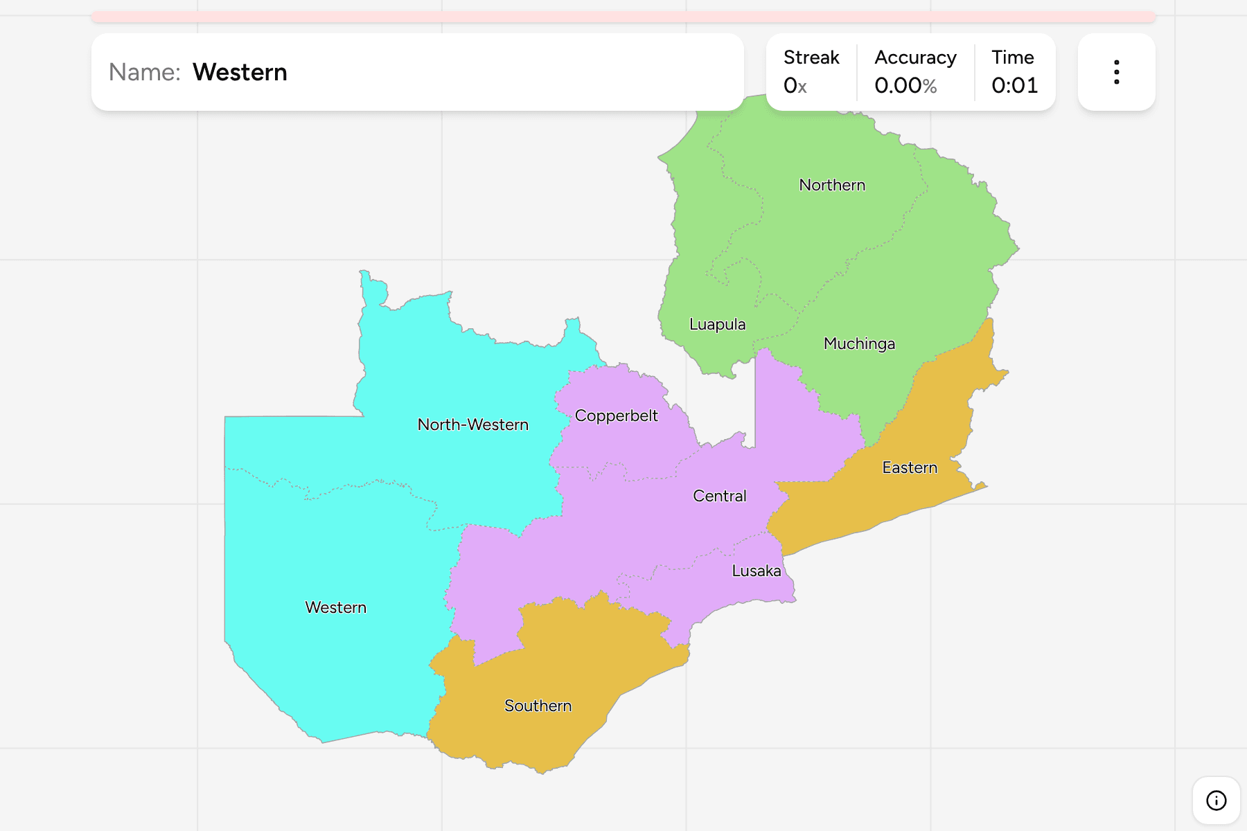
The ten provinces of Zambia, as they have stood since Muchinga was cut out of
the Northern and Eastern provinces in 2011. Most are named for a direction:
Northern, Southern, Eastern, Western, North-Western and Central. The other four
are named for a place or a landmark: Lusaka around the capital, the Copperbelt
on the Congolese border, Luapula after its river, and Muchinga after the
escarpment.
The two biggest are Western and North-Western, which together fill the west of
the country, and Western is the one with the Zambezi floodplain. Lusaka is the
smallest, a compact province around the capital, and the Copperbelt is the next
smallest, a block of mining towns on the border with the Democratic Republic of
the Congo. Southern runs along the Zambezi and Lake Kariba, the border with
Zimbabwe.
The groups are not an official classification. Zambia has no tier between the
province and the country, so the quiz cuts the ten into the north, the centre,
the west, and the south and east, to let you drill the map a piece at a time.
The provinces are the Zambia Districts grouped, so the
borders of the two maps match exactly.
How to place one
- Start with Lusaka and the Copperbelt. They are the two small provinces in
the middle of the country, and almost everything else is measured from them.
- Take the west as two big pieces. North-Western and Western fill the whole
side of the map, with North-Western on top.
- Run the north as a row. Luapula, Northern and Muchinga go from the
Congolese border in the north west to the Malawian border in the east.
- Finish along the south. Southern is the long province on the Zimbabwean
border, and Eastern is the one that reaches Malawi and Mozambique.
Every province, by group
- North3 provinces
- Luapula, Muchinga, Northern
- Centre3 provinces
- Central, Copperbelt, Lusaka
- West2 provinces
- North-Western, Western
- South and East2 provinces
- Eastern, Southern
Worked examples
WesternThe biggest of themWestern is the largest province, a wide run of sand and floodplain along the
Angolan border. The Zambezi runs through it, and the floodplain around Mongu
is the home of the Lozi people.
LusakaThe one around the capitalLusaka is the smallest province, made up of the capital and the districts
around it. It is a province of the plateau, with Southern and Central on its
sides and the Zambezi on its southern border with Zimbabwe.
MuchingaThe one that is newMuchinga is the youngest province, created in 2011 from parts of Northern and
Eastern. Older maps show nine provinces and no Muchinga, with Northern
reaching all the way to the Malawian border.
Frequently asked questions
How many provinces does Zambia have?
Ten. Muchinga was added in 2011, so a map from before then shows nine.
Why are the groups not official?
Zambia has no administrative tier between the provinces and the country, so the quiz groups the ten into four parts of the map by position.
What is below the province?
The districts, which number 116. They are their own quiz.
The tier below this one is Zambia Districts. For another
country at this level, see Rwanda Provinces.
Sources