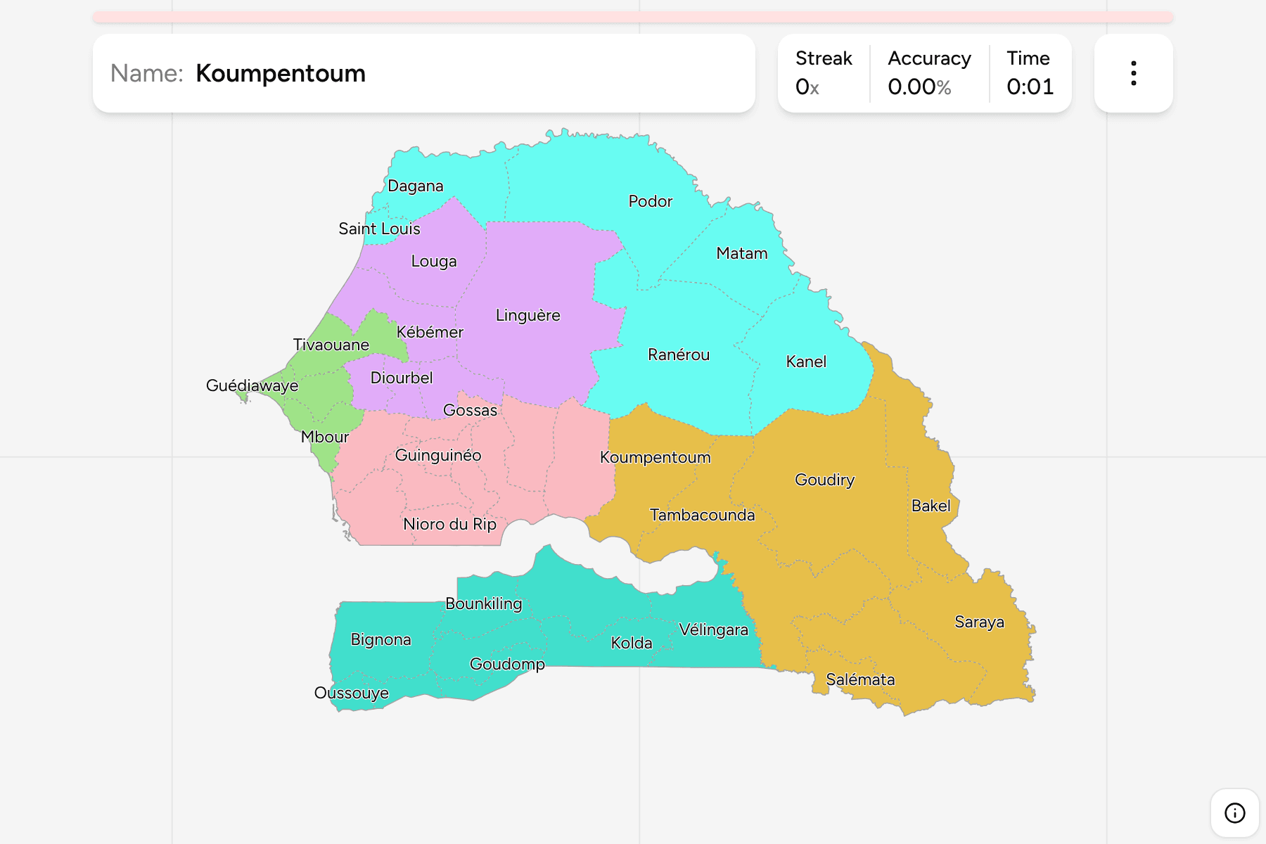
Senegal's 14 regions are divided into 46 departments, the tier that sits
directly under them and the one the state actually runs: each has a prefect
appointed from Dakar, and the towns that give them their names are where most
people go for their papers. The map is easy to start and slow to finish, since
the Gambia cuts it in two and the departments around Dakar are a few kilometres
across. This page is all 46, the groups to learn them in, and the changes that
make a lot of printed maps wrong.
- The quiz
- Name to place, on the map
- Where it helps
- North or south of the Gambia, coast versus interior, the Dakar suburbs
- In the game
- 46 departments
What you are looking at
A department is named after its main town, and most of the 46 are the size of
a county: three to five to a region, with Dakar holding five and Kaffrine and
Tambacounda four each. The departments are split further into arrondissements
and then into communes, which the game does not ask for.
The number that matters is 46. The country had 45 departments for most of
the 2010s, and a map older than 2021 has one fewer. Pikine, the dense suburb
east of Dakar, was divided that year and Keur Massar was cut out of its
north east. Several widely used open datasets still draw the 45, which is why
this game is built from a source that was revised later.
How to place one
- Decide which side of the Gambia you are on. South of it is Casamance:
Ziguinchor, Kolda and Sédhiou regions, nine departments between them, all
humid, green and low.
- Then find the Dakar peninsula. Dakar, Pikine, Guédiawaye, Keur Massar and
Rufisque are five departments in a hand's width of the west coast. Dakar is
the tip, Rufisque is the large one reaching inland along the coast, and the
three between them are tiny.
- Then find the river. The Senegal River is the border with Mauritania, and
the departments along it, Podor and Dagana in Saint-Louis region and Matam,
Kanel and Bakel upstream, are a strip of irrigated fields with desert on
either side.
- Then narrow inside the group. The six groups below are two or three
regions each, and each can be switched on and off in the start dialog, which
is the fastest way to learn them.
The traps are the departments that share a name with their region, the east
and the delta.
Saint Louis, Louga, Kolda and Diourbel are also regions. The department of
that name is the area around the town, and it is always smaller than the region
that carries the name. Saint Louis is a small coastal department at the mouth
of the river, and the rest of its region is Dagana and Podor.
Linguère is not Louga. Linguère is the largest department of Senegal, a
huge, near empty block of Sahelian pastureland in the interior of Louga region
that reaches almost to the river. Louga itself is a modest department on the
coast.
Kédougou has hills, Tambacounda has distance. The south eastern departments
around Kédougou and Saraya are the greenest part of the east, with the foothills
of the Fouta Djallon along the Guinean border. North of them the land flattens into dry plain, and Goudiry and Tambacounda
are two of the giants.
Every department, by group
- Cap-Vert and Thiès8 departments
- Dakar, Guédiawaye, Keur Massar, Mbour, Pikine, Rufisque, Thiès, Tivaouane
- Diourbel6 departments
- Bambey, Diourbel, Kébémer, Linguère, Louga, Mbacké
- Fleuve6 departments
- Dagana, Kanel, Matam, Podor, Ranérou, Saint Louis
- Sénégal Oriental7 departments
- Bakel, Goudiry, Kédougou, Koumpentoum, Salémata, Saraya, Tambacounda
- Casamance9 departments
- Bignona, Bounkiling, Goudomp, Kolda, Médina-Yorofoula, Oussouye, Sédhiou, Vélingara, Ziguinchor
- Sine-Saloum10 departments
- Birkelane, Fatick, Foundiougne, Gossas, Guinguinéo, Kaffrine, Kaolack, Koungheul, Malem-Hodar, Nioro du Rip
Those groups are the ones senegal-regions uses, and older than any of the
regions. They are the seven regions the country had at independence, with the
two smallest, Cap-Vert and Thiès, put together, so a player who has learned the
regions meets the same colours here. Every one of today's departments sits
inside exactly one of those groups.
Worked examples
LinguèreThe largestLinguère: the whole interior of Louga region, from the edge of the groundnut
basin to the Ferlo, a flat, thorny pastureland where herders move cattle
between boreholes. It is the largest department by a wide margin and one of
the emptiest, so if the picture is open scrub and almost no villages, this is
the likeliest answer.
Keur MassarThe newestKeur Massar: the north eastern part of what used to be Pikine, a dense and
fast growing suburb of the capital. It was made a department in 2021, so it is
the one most often missing from older maps, and it is one of the three
smallest on the map, hemmed in by Pikine, Rufisque and Guédiawaye.
OussouyeSouth of the Gambia, and on the coastOussouye: the south west corner of the country, between the Casamance river
and the border with Guinea-Bissau, a department of mangroves and rice fields
that includes Cap Skirring and the coast around it. It is one of the smallest
departments outside the Dakar suburbs.
Frequently asked questions
How many departments does Senegal have?
46, since Keur Massar was created in 2021. Before that Senegal had 45, and many maps and datasets still show that number. The departments are grouped into 14 regions.
What is the difference between a region and a department in Senegal?
The region is the top tier, headed by a governor, and the department is the tier directly under it, headed by a prefect. Every region holds between three and five departments. Below the department are the arrondissements, and below those the communes, which are the elected local councils.
Which is the largest department of Senegal, and which the smallest?
Linguère, in the interior of Louga region, is the largest, and Guédiawaye, on the coast beside Dakar, is the smallest. Guédiawaye is a dense suburb of a few dozen square kilometres.
Which departments are in the Dakar region?
Five: Dakar, Pikine, Guédiawaye, Keur Massar and Rufisque. Together they hold close to a quarter of the country's people on a small fraction of one percent of its land.
Why do some departments have the same name as their region?
Because both are named for the same town. Saint Louis, Louga, Kolda, Diourbel, Kaolack, Fatick, Kaffrine, Matam, Tambacounda, Kédougou, Sédhiou, Thiès, Dakar and Ziguinchor are each a region and a department with the same name, and the department is the area around the town while the region is everything its prefects share.
Why is the Gambia inside Senegal?
The Gambia is a separate country, a strip along both banks of the Gambia River that was a British colony while Senegal around it was French. It reaches the Atlantic, so it is not an enclave, but it separates Casamance, in the south, from the rest of Senegal by land.
For the tier above, try Senegal Regions. The other
African trainers here are Morocco Provinces, South Africa
Districts, Ghana Regions and
Tunisia Governorates. For second tiers of a similar
size, try Austria Districts and Bulgaria
Municipalities.
Sources