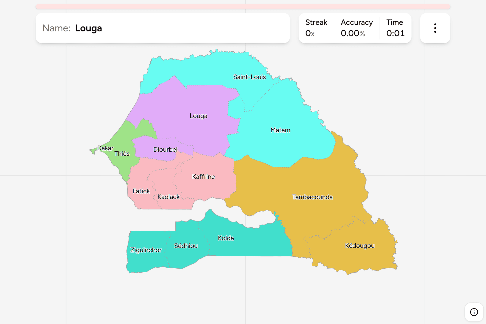
Senegal has 14 regions, each named after the town that runs it, wrapped around
a country that is not Senegal at all: the Gambia runs 300km into it along its
river and cuts the south off from the rest. That makes the map easier to learn
than most, because the Gambia is a landmark nobody can miss, and harder to
trust, because a great deal of what is printed still shows the eleven regions
from before 2008. This page is all fourteen, the older regions they were cut
out of, and what tells you which one you are in.
- The quiz
- Name to place, on the map
- Where it helps
- Plate codes, north or south of the Gambia, coast versus interior
- In the game
- 14 regions
What you are looking at
The region is the top tier of Senegal's administration. Each has a governor
appointed by the state and an elected council, and is divided into departments,
of which the country has 46. Every region is named after its capital, so here,
unlike Ghana, knowing the towns is most of knowing the map: Kaolack is the
capital of Kaolack and Ziguinchor of Ziguinchor.
The number that matters is 14. Senegal had eleven regions from 2002 and ten
before that. In 2008 three more were cut out of existing ones:
- Kaffrine out of the eastern half of Kaolack.
- Kédougou out of the south east corner of Tambacounda.
- Sédhiou out of the western third of Kolda.
Matam had been cut out of the eastern end of Saint-Louis in 2002. A map
with no Kaffrine on it, or with Tambacounda running all the way to the Guinean
border, is a map from before 2008.
A Senegalese plate names a region. Plates issued from 1989 to 2019 open with
a two-letter code for the region that registered the vehicle, DK for Dakar and
TH for Thiès, and the current format carries the region code in a panel at the
side. Older plates are still everywhere, so the code at the front of a white on
blue plate is one of the most direct clues the country offers.
How to place one
- Decide which side of the Gambia you are on. South of it is Casamance:
Ziguinchor, Sédhiou and Kolda. Casamance is a different country to look at:
green, wet, with rice paddies, palms and dense forest where the north is dry
savannah and sand. If it is lush and you are near the sea, it is Ziguinchor.
- Then decide coast or interior. Six regions touch the Atlantic: Saint-Louis,
Louga, Thiès, Dakar and Fatick north of the Gambia, and Ziguinchor south of it.
Everything else is inland.
- Then find the river. The Senegal River is the northern and eastern border
with Mauritania and Mali, and the two regions along it, Saint-Louis and
Matam, are the valley: irrigated fields in a strip along the water with
near-desert on either side.
- Then narrow inside the group. The six groups below are two or three
regions each, and each can be switched on and off on its own in the game's
start dialog, which is the fastest way to learn them.
The traps are two of the pairs split in 2008 and the strip of small regions in the
west.
Kaolack is the small one and Kaffrine the big one. They are two halves of
the strip along the northern border of the Gambia, with Kaolack at the western
end around its city and Kaffrine taking the rest, east as far as Tambacounda.
Tambacounda is not in the corner. It is the largest region and holds most
of the east, but the south east corner, the hilliest part of the country, is
Kédougou.
Diourbel and Fatick are not interchangeable. Diourbel is the small inland
region between Thiès and Louga, around Diourbel and Touba, the holy city of the
Mouride brotherhood and the second largest city in the country. Fatick, below
it, is the one that wraps around the Saloum delta and reaches the sea.
Every region, by group
- Cap-Vert and Thiès2 regions
- Dakar, Thiès
- Diourbel2 regions
- Diourbel, Louga
- Fleuve2 regions
- Matam, Saint-Louis
- Sénégal Oriental2 regions
- Kédougou, Tambacounda
- Casamance3 regions
- Kolda, Sédhiou, Ziguinchor
- Sine-Saloum3 regions
- Fatick, Kaffrine, Kaolack
Those groups are Senegal's own, and older than any of its regions. They are
the seven regions the country had at independence, with the two smallest,
Cap-Vert and Thiès, put together. Every one of today's fourteen was cut out of
exactly one of the seven, so a player who knows the old map finds each new name
where its parent was. Cap-Vert was renamed Dakar in 1984; the same year the
Fleuve became Saint-Louis, Sénégal Oriental became Tambacounda, and Sine-Saloum
and Casamance were each split in two. Louga had already been cut out of
Diourbel, in 1976.
Three of those old names are still in everyday use for the places they
named. Casamance is what everybody calls the south below the Gambia.
The Fleuve, the river, is the Senegal River valley along the northern
border. Sine-Saloum is the groundnut basin, named for its two rivers, and
Fatick, Kaolack and Kaffrine between them still grow a large share of the
country's groundnuts. Sénégal Oriental, eastern Senegal, is the dry, sparsely
populated east around Niokolo-Koba National Park and the hills along the
Guinean border.
Worked examples
TambacoundaThe largestTambacounda: most of the east of the country, from the eastern end of the
Gambia to the Malian border along the Falémé, with its capital a railway town
on the old Dakar to Niger line. It is the largest of the 14 by a long way and
one of the least populated. Dry savannah, long straight roads and very few
towns: if you are in the east and not among hills, this is the likeliest
answer.
DakarThe smallest, and the capitalDakar: the Cap-Vert peninsula, the westernmost point of mainland Africa, and
much the smallest region on the map. It holds close to a quarter of the
country's people on a small fraction of one percent of its land, so it is the
easy answer for anything dense, urban and by the sea.
ZiguinchorSouth of the Gambia, and on the coastZiguinchor: the lower Casamance, from the Atlantic at Cap Skirring up the
estuary to its capital and beyond, with Guinea-Bissau along its southern
border. It is the wettest and greenest part of the country, all mangroves,
rice fields and palm forest, and it is the only region south of the Gambia
that reaches the sea.
Frequently asked questions
How many regions does Senegal have?
14, since 2008. Senegal had seven regions at independence; Louga was created out of Diourbel in 1976, and in 1984 Sine-Saloum was split into Kaolack and Fatick and Casamance into Ziguinchor and Kolda, making ten. Matam was created out of Saint-Louis in 2002, and in 2008 Kaffrine was created out of Kaolack, Kédougou out of Tambacounda and Sédhiou out of Kolda.
What are the capitals of Senegal's regions?
Every region is named after its capital, so the capital of Dakar is Dakar, the capital of Thiès is Thiès, and so on for all fourteen. Dakar is also the national capital. Saint-Louis, on the northern coast at the mouth of the Senegal River, was the capital of the colony of Senegal and of French West Africa until Dakar replaced it.
Do Senegalese number plates show the region?
Yes. Plates issued between 1989 and 2019 open with a two-letter code for the region the vehicle was registered in, such as DK for Dakar and TH for Thiès, followed by a number and a letter. The current format, from 2019, keeps the region code in a panel at the side of the plate. Both formats are on the road.
Which is the largest region of Senegal, and which the smallest?
Tambacounda, in the east, is the largest by area, and Dakar is much the smallest. Dakar is also by far the most populous, holding close to a quarter of the country's population.
Why is the Gambia inside Senegal?
The Gambia is a separate country, a strip along both banks of the Gambia River that was a British colony while Senegal around it was French. It reaches the Atlantic, so it is not an enclave, but it separates Casamance, the three southern regions of Ziguinchor, Sédhiou and Kolda, from the rest of Senegal by land.
Which Senegalese regions are easiest to confuse?
The pairs split in 2008: Kaolack and Kaffrine, Tambacounda and Kédougou, and Kolda and Sédhiou, where the newer region sits right beside the one it came from. Among the small western regions, Diourbel and Fatick are the other common mix-up: Diourbel is the small inland region around Touba, Fatick the one that wraps around the Saloum delta and reaches the sea.
What language are road signs in Senegal?
French, which is Senegal's official language. Wolof is the most widely spoken language in the country and is common on shopfronts and painted signs, but official road signs and place name signs are in French.
The other African trainers here are Ghana Regions, Nigeria
States, Kenya Counties, Egypt
Governorates, Morocco Regions,
Tunisia Governorates, South Africa
Provinces and South Africa Dialing
Codes. For administrative maps of a similar size,
try Germany States, Canada
Provinces and UK Nations and Regions.
Sources