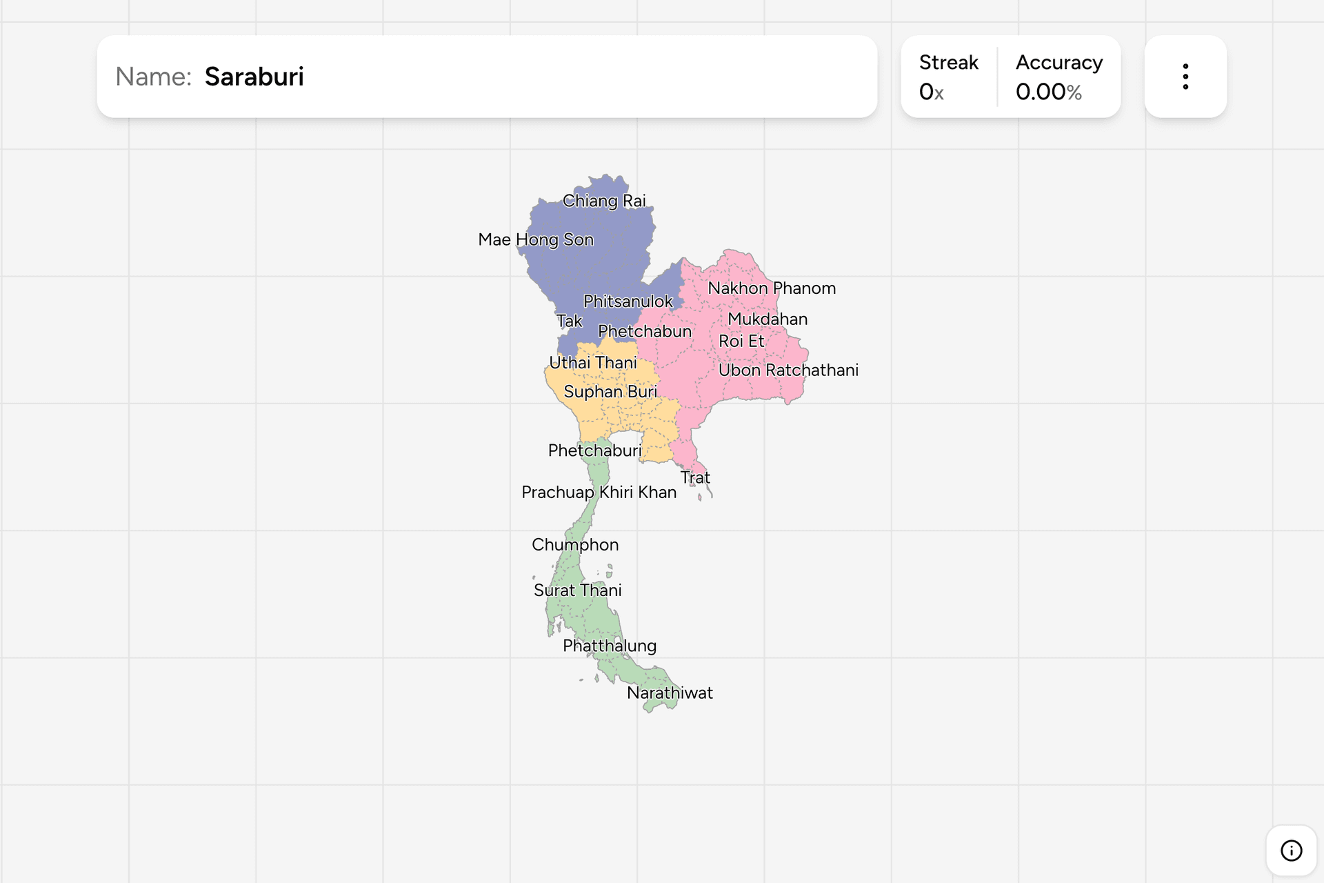
Thailand is divided into changwat, provinces, and nearly every one of them is
named after its own capital town. That is the single most useful fact about
this map: a town name on a road sign is usually also a province name, and
knowing where the province is turns a sign you cannot pronounce into a
location. This page is the whole list, grouped the way the game groups it.
- The quiz
- Name to place, on the map
- Grouped by
- Part of the country
- In the game
- 77 provinces
What you are looking at
A changwat is run by a governor appointed from Bangkok, and it is divided into
districts (amphoe) below that. The province and its capital share a name, and
the capital district is called Mueang plus the province name: Mueang Chiang Mai
is the town of Chiang Mai inside the province of Chiang Mai. Signs use both, so
a name that appears with Mueang in front of it is a town rather than the
province around it.
Bangkok is the odd one out. It is not a changwat but a special administrative
area with an elected governor, the only place in the country that elects one,
and it sits in the list anyway because on a map it behaves like a province.
The names look harder than they are. Most of them are compounds of a few
recurring words: buri for a town or fortified city (Lop Buri, Sing Buri, Buri
Ram), nakhon for a large city (Nakhon Sawan, Nakhon Phanom, Nakhon Pathom),
thani for a place (Udon Thani, Surat Thani, Pathum Thani), samut for sea
(Samut Prakan, Samut Sakhon, Samut Songkhram) and nong or bueng for a lake or
marsh (Nong Khai, Bueng Kan). Learning the words is faster than learning
seventy seven separate strings.
How to place one
- Get the part of the country. Thailand is four shapes: the northern
mountains, the northeastern plateau (Isan) inside the bend of the Mekong,
the central plain around Bangkok, and the peninsula running south to
Malaysia.
- Anchor on the borders. The Mekong draws the entire northeastern edge, so
any province with a river border is in Isan. The peninsula is a line of
provinces alternating between the Gulf side and the Andaman side. The
northern provinces stack against Myanmar and Laos.
- Then use the name. Nakhon Ratchasima is the gateway to Isan, Chiang Mai
anchors the north, Surat Thani and Songkhla the peninsula, and most other
names sit within one province of one of those.
The pairs to be careful with are the ones that differ by a syllable. Nong Khai
is on the Mekong, Nong Bua Lam Phu is inland below it. Chai Nat is in the
central plain, Chaiyaphum is in Isan. Phichit and Phitsanulok are neighbours in
the north of the central plain and are constantly swapped. The three Samut
provinces all sit within an hour of Bangkok on the Gulf, and only their order
along the coast separates them.
Every province, by part of the country
- North15 provinces
- Chiang Rai, Chiang Mai, Mae Hong Son, Tak, Phayao, Nan, Uttaradit, Phitsanulok, Loei, Kamphaeng Phet, Lampang, Sukhothai, Phichit, Phrae, Lamphun
- East23 provinces
- Surin, Si Sa Ket, Ubon Ratchathani, Sa Kaeo, Buri Ram, Trat, Chanthaburi, Bueng Kan, Nong Khai, Nakhon Phanom, Mukdahan, Amnat Charoen, Khon Kaen, Sakon Nakhon, Nakhon Ratchasima, Kalasin, Roi Et, Maha Sarakham, Nong Bua Lam Phu, Udon Thani, Phetchabun, Chaiyaphum, Yasothon
- Central23 provinces
- Kanchanaburi, Ratchaburi, Samut Songkhram, Samut Sakhon, Bangkok Metropolis, Samut Prakan, Chachoengsao, Chon Buri, Rayong, Suphan Buri, Sing Buri, Chai Nat, Ang Thong, Saraburi, Nakhon Nayok, Pathum Thani, Uthai Thani, Lop Buri, Phra Nakhon Si Ayutthaya, Nonthaburi, Nakhon Pathom, Nakhon Sawan, Prachin Buri
- South16 provinces
- Satun, Songkhla, Yala, Narathiwat, Prachuap Khiri Khan, Phetchaburi, Chumphon, Ranong, Phangnga, Krabi, Trang, Pattani, Phatthalung, Nakhon Si Thammarat, Surat Thani, Phuket
The four groups are the game's own division of the map, and the eastern group
is essentially Isan plus the seaboard southeast of Bangkok. Any group can be
switched on and off on its own in the start dialog, which is how a map of
seventy seven names becomes four evenings rather than one impossible one.
Worked examples
Bangkok MetropolisNot a provinceThe capital, the only place in Thailand that elects its own governor, and not
technically a province at all. On the map it is the small dense area at the
head of the Gulf where the Chao Phraya reaches the sea, hemmed in by the
central plain provinces on three sides.
PhuketThe island provinceThe only province that is entirely an island, on the Andaman coast, and one
of the smallest by area. It is the name in the peninsula most people already
know, which makes it a good anchor: everything else on the west coast is
counted north or south from here.
Nakhon RatchasimaThe gateway to IsanThe largest province in the country by area, at the southwestern corner of
the Isan plateau, and the road and rail gateway between Bangkok and the
northeast. Also known as Khorat, which is the name you are more likely to see
on a bus.
Bueng KanThe newest provinceThe newest province, created in 2011 out of the top of Nong Khai on the
Mekong bend. Newly created provinces are the ones missing from older maps and
older quizzes, so if you learned this map years ago, this is the click you
will not expect.
Frequently asked questions
How many provinces does Thailand have?
76 provinces plus Bangkok, which is a special administrative area rather than a province, so 77 units in total on a map. The newest of them is Bueng Kan, split from Nong Khai in 2011.
Are Thai provinces named after their capital cities?
Nearly always. A province and its principal town share a name, and the town itself is the Mueang district of that province: Mueang Chiang Mai is the town, Chiang Mai is the province around it. That is why reading a town name off a road sign is usually enough to place the province.
What do buri, nakhon and thani mean in Thai place names?
They are the recurring building blocks of Thai place names. Buri means town or fortified city, nakhon means a great city, and thani also means a town or place. Samut means sea, nong and bueng mean a lake or marsh, and chiang means a walled city in the northern dialect. Knowing a dozen of these makes the whole list easier to hold.
What are the regions of Thailand?
The most common division is four: the north with its mountains and Chiang Mai, the northeast or Isan on the Khorat plateau inside the bend of the Mekong, the central plain around Bangkok and the Chao Phraya, and the south along the peninsula towards Malaysia. Some official schemes use six regions instead, splitting off the east and the west.
Which Thai provinces are easiest to confuse?
Nong Khai and Nong Bua Lam Phu, Chai Nat and Chaiyaphum, and Phichit and Phitsanulok, which differ by a syllable but sit in different parts of the country. The three Samut provinces around Bangkok are another set: they are neighbours, so only their order along the Gulf coast tells them apart.
More administrative maps in the region: Vietnam
Provinces, Philippines
Provinces, India States and Japan
Prefectures.
Sources