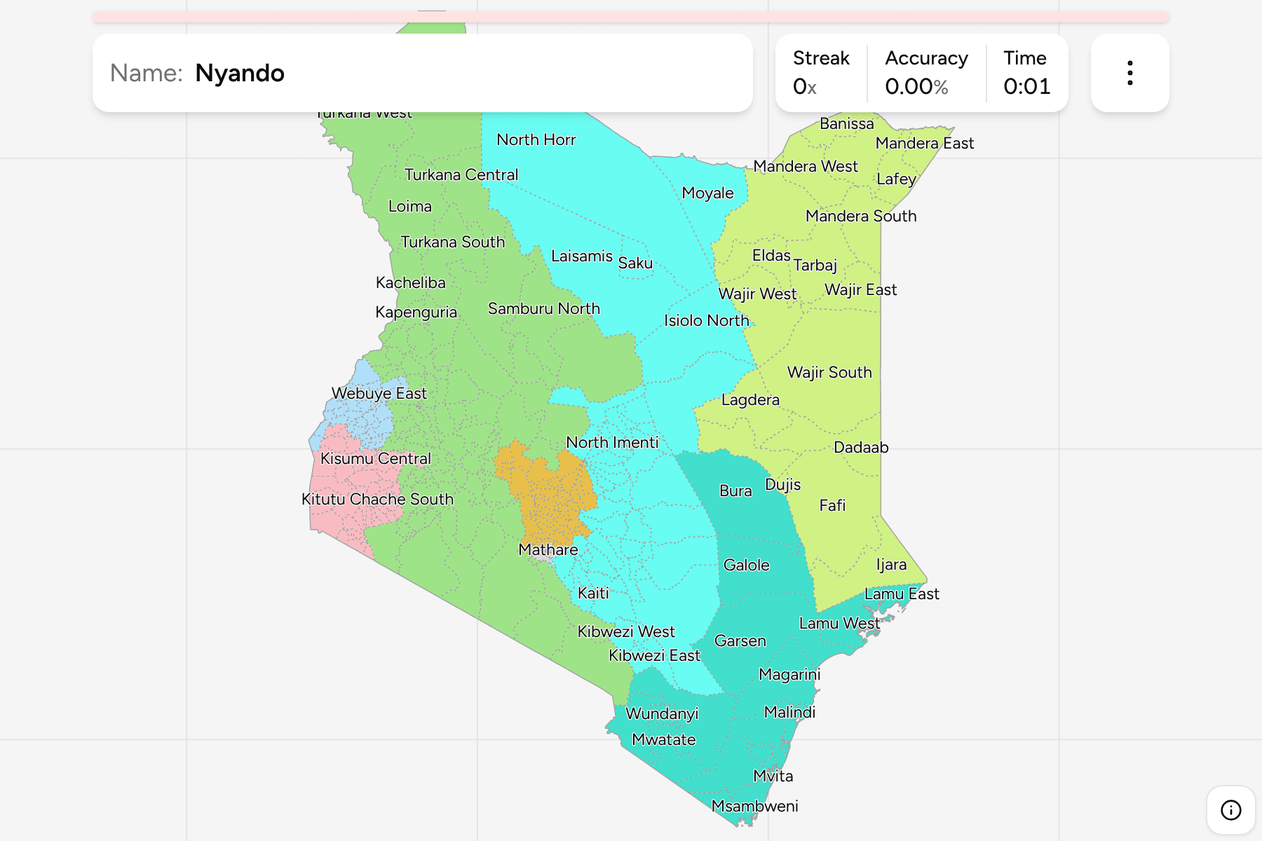
The constituency is the tier of Kenya that people vote in: one member of
parliament each, 290 of them, nested inside the 47 counties. It is the name a
campaign poster, a bursary notice or a news bulletin gives you, and this page is
all of them, grouped by the old province they sit in.
Kenya's constituencies are drawn for elections, and the constitution fixes how
many there are: 290, each wholly inside one county. The count is exact and
stable, which is why the map is worth learning. The 2010 constitution kept the
constituencies when it created the counties, and the counties took over most of
what the districts used to do. What stayed with the constituency is the seat in
the National Assembly and a development fund of its own.
They are very uneven, because they were drawn on population. Nairobi has
seventeen, packed into a city you can drive across in an hour, and Kiambu and
Kakamega have twelve each. At the other end Laikipia, which is larger than
Nairobi many times over, has three, and Isiolo and Lamu have two apiece. The
north and east are a handful of enormous constituencies, while the western
highlands are a mosaic of small ones that the map draws a tap area for.
Some names are used by the sources under more than one form, and the game
uses the one on the ballot: Dagoretti North and Dagoretti South are the
two Dagoretti constituencies, Mbeere North and Mbeere South are the
Embu constituencies older maps label Siakago and Gachoka, and Chuka/Igambang'ombe
is the one in Tharaka-Nithi that is sometimes just called Nithi.
- Rift Valley76 constituencies
- Ainabkoi, Ainamoi, Aldai, Bahati, Baringo Central, Baringo North, Baringo South, Belgut, Bomet Central, Bomet East, Buret, Chepalungu, Cherangany, Chesumei, Eldama Ravine, Emgwen, Emurua Dikirr, Endebess, Gilgil, Kacheliba, Kajiado Central, Kajiado East, Kajiado North, Kajiado South, Kajiado West, Kapenguria, Kapseret, Keiyo North, Keiyo South, Kesses, Kilgoris, Kiminini, Kipkelion East, Kipkelion West, Konoin, Kuresoi North, Kuresoi South, Kwanza, Laikipia East, Laikipia North, Laikipia West, Loima, Marakwet East, Marakwet West, Mogotio, Moiben, Molo, Mosop, Naivasha, Nakuru Town East, Nakuru Town West, Nandi Hills, Narok East, Narok North, Narok South, Narok West, Njoro, Pokot South, Rongai, Saboti, Samburu East, Samburu North, Samburu West, Sigor, Sigowet, Sotik, Soy, Subukia, Tiaty, Tinderet, Turbo, Turkana Central, Turkana East, Turkana North, Turkana South, Turkana West
- Nairobi17 constituencies
- Dagoretti North, Dagoretti South, Embakasi Central, Embakasi East, Embakasi North, Embakasi South, Embakasi West, Kamukunji, Kasarani, Kibra, Langata, Makadara, Mathare, Roysambu, Ruaraka, Starehe, Westlands
- Eastern44 constituencies
- Buuri, Central Imenti, Chuka, Igembe Central, Igembe North, Igembe South, Isiolo North, Isiolo South, Kaiti, Kangundo, Kathiani, Kibwezi East, Kibwezi West, Kilome, Kitui Central, Kitui East, Kitui Rural, Kitui South, Kitui West, Laisamis, Maara, Machakos Town, Makueni, Manyatta, Masinga, Matungulu, Mavoko, Mbeere North, Mbeere South, Mbooni, Moyale, Mwala, Mwingi East, Mwingi North, Mwingi West, North Horr, North Imenti, Runyenjes, Saku, South Imenti, Tharaka, Tigania East, Tigania West, Yatta
- Central34 constituencies
- Gatanga, Gatundu North, Gatundu South, Gichugu, Githunguri, Juja, Kabete, Kandara, Kangema, Kiambaa, Kiambu, Kieni, Kigumo, Kiharu, Kikuyu, Kinangop, Kipipiri, Kirinyaga Central, Lari, Limuru, Maragwa, Mathioya, Mathira, Mukurweni, Mwea, Ndaragwa, Ndia, Nyeri Town, Ol Joro Orok, Ol Kalou, Othaya, Ruiru, Tetu, Thika Town
- Coast26 constituencies
- Bura, Changamwe, Galole, Ganze, Garsen, Jomvu, Kaloleni, Kilifi North, Kilifi South, Kinango, Kisauni, Lamu East, Lamu West, Likoni, Lunga Lunga, Magarini, Malindi, Matuga, Msambweni, Mvita, Mwatate, Nyali, Rabai, Taveta, Voi, Wundanyi
- Nyanza42 constituencies
- Alego Usonga, Awendo, Bobasi, Bomachoge Borabu, Bomachoge Chache, Bonchari, Bondo, Borabu, Gem, Homa Bay, Kabondo Kasipul, Karachuonyo, Kasipul, Kisumu Central, Kisumu East, Kisumu West, Kitutu Chache North, Kitutu Chache South, Kitutu Masaba, Kuria East, Kuria West, Muhoroni, Ndhiwa, North Mugirango, Nyakach, Nyando, Nyaribari Chache, Nyaribari Masaba, Nyatike, Rangwe, Rarieda, Rongo, Seme, South Mugirango, Suba North, Suba South, Suna East, Suna West, Ugenya, Ugunja, Uriri, West Mugirango
- Western33 constituencies
- Budalangi, Bumula, Butere, Butula, Emuhaya, Funyula, Hamisi, Ikolomani, Kabuchai, Kanduyi, Khwisero, Kimilili, Likuyani, Luanda, Lugari, Lurambi, Malava, Matayos, Matungu, Mt. Elgon, Mumias East, Mumias West, Nambale, Navakholo, Sabatia, Shinyalu, Sirisia, Teso North, Teso South, Tongaren, Vihiga, Webuye East, Webuye West
- North Eastern18 constituencies
- Balambala, Banissa, Dadaab, Dujis, Eldas, Fafi, Ijara, Lafey, Lagdera, Mandera East, Mandera North, Mandera South, Mandera West, Tarbaj, Wajir East, Wajir North, Wajir South, Wajir West
Those are the eight provinces Kenya had from independence until 2013. They have
no legal existence now, but Kenyans still place each other by them, and every
constituency sits inside exactly one because the counties were built from the
districts the provinces held. Each can be turned on and off in the start dialog.