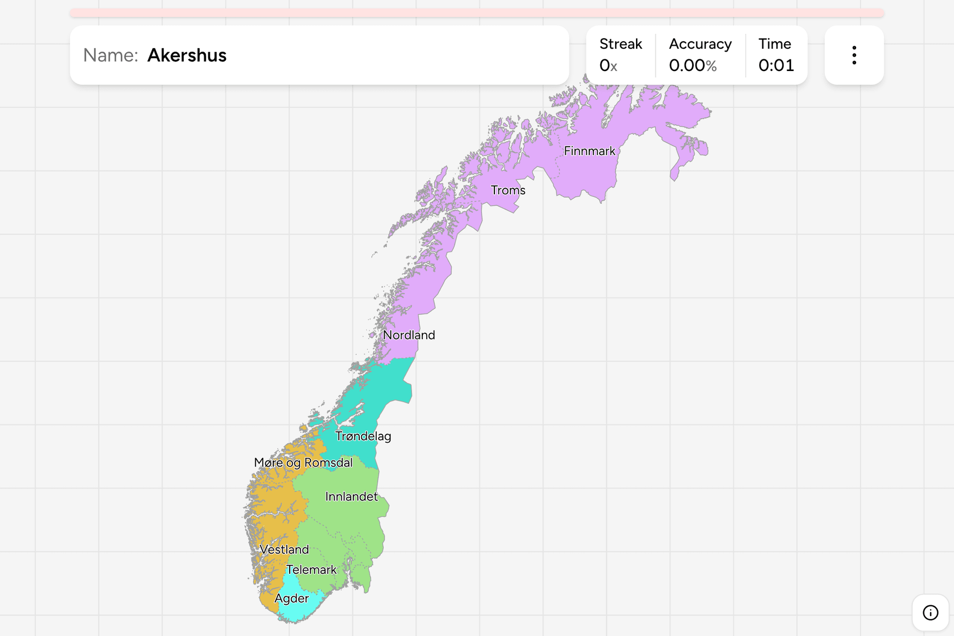
Norway is a long country, and knowing you are in it says little about where:
Kirkenes is farther from Oslo than Paris is. The county, or fylke, is the
unit that fixes it. Each has an elected county council that runs upper
secondary schools, county roads and public transport, and a governor appointed
by the state. The map changed twice in five years, so most atlases and most
memories are out of date: this page and the game follow the 15 counties in force
since 2024.
- The quiz
- Name to place, on the map
- Grouped by
- Landsdel: Østlandet, Sørlandet, Vestlandet, Trøndelag, Nord-Norge
- In the game
- 15 counties
What you are looking at
In 2020 the 18 counties of the day were merged into 11. Three of the new ones
were large mergers imposed from above: Viken (Østfold, Akershus and Buskerud),
Vestfold og Telemark, and Troms og Finnmark. All three were undone with effect
from 1 January 2024, which is why the map here has Østfold, Akershus, Buskerud,
Vestfold, Telemark, Troms and Finnmark as separate counties again. The mergers
that were kept are Innlandet (Hedmark and Oppland), Agder (the two Agders),
Vestland (Hordaland and Sogn og Fjordane) and Trøndelag, which dates from 2018.
Oslo is both a county and a municipality, and is the one county that is a single
shape on the map. Svalbard belongs to Norway but is not a county, and is not
drawn here.
Above the counties sit the five landsdeler, which have no government and are
older than all of them. Østlandet is the south east around the capital and
holds more than half the population. Sørlandet is the south coast, Vestlandet
the fjords and the oil coast, Trøndelag the middle, and Nord-Norge everything
from Nordland north.
How to place one
- Get the landsdel first. Nord-Norge is the three long counties of the
north, Vestlandet the three on the west coast, and Østlandet the seven round
Oslo. Sørlandet and Trøndelag are one county each.
- Read the name. Several are the old provinces or valleys they take their
name from: Innlandet is simply "the inland", Agder is the old kingdom on the
south coast, and Møre og Romsdal is two districts in one name.
- Count outward from Oslo. Akershus wraps the capital on three sides,
Østfold is the south east corner, Buskerud, Vestfold and Telemark run west
along the Oslofjord, and Innlandet fills the interior behind them.
- Use the coast. From the Swedish border round the south and up: Østfold,
Akershus, Oslo, Vestfold, Telemark, Agder, Rogaland, Vestland, Møre og
Romsdal, Trøndelag, Nordland, Troms, Finnmark.
Every county, by landsdel
- Østlandet7 counties
- Oslo, Østfold, Akershus, Buskerud, Innlandet, Vestfold, Telemark
- Nord-Norge3 counties
- Nordland, Troms, Finnmark
- Sørlandet1 county
- Agder
- Vestlandet3 counties
- Rogaland, Møre og Romsdal, Vestland
- Trøndelag1 county
- Trøndelag
Worked examples
OsloThe one that is only a cityOslo is a county of its own that is also a single municipality, tucked into the
head of the Oslofjord. Akershus surrounds it on land, so the quickest way to find
the capital is to find the county that has a hole in it.
FinnmarkThe top of the mapFinnmark is the northernmost and the largest county by area, and borders both
Finland and Russia. It was part of Troms og Finnmark from 2020 until the split
in 2024, so a map older than that shows it without a border to its south.
VestlandThe fjord countyVestland was formed in 2020 from Hordaland and Sogn og Fjordane, and holds
Bergen, the second largest city, and the Sognefjord. Unlike the three
mergers undone in 2024, it kept its 2020 shape.
Frequently asked questions
How many counties does Norway have?
15, since 1 January 2024. There were 18 until the end of 2019, 11 from 2020, and the three largest mergers were reversed in 2024.
What is a Norwegian county called?
A fylke (plural: fylker). Each has a county council, the fylkesting, and a county governor appointed by the state.
Why do older maps show different counties?
Because of the 2020 merger and its partial reversal. Viken, Vestfold og Telemark and Troms og Finnmark appear on maps from 2020 to 2023 and nowhere else.
Is Svalbard a county?
No. It is administered directly by a governor under its own law, and is not one of the 15 counties or drawn in this game.
What are Østlandet, Vestlandet and the others?
The landsdeler, the traditional parts of the country. They are not administrative divisions, but they are how Norwegians say where something is, and they are the groups this game is cut by.
The tier below this one is Norway Municipalities, and
the 15 answers here are the 15 groups there, so it is the place to go once the
counties come easily. For another country at this level, see
Sweden Counties and Netherlands Provinces.
Sources
- Fylker og kommuner, by robhop, Kartverket's 2024 boundaries, clipped to the coastline, which the counties here are dissolved from
- Counties of Norway, the 15 counties, and the history of the 2020 mergers and their reversal
- Traditional districts of Norway, Østlandet, Sørlandet, Vestlandet and the rest, the groups this game uses