Sri Lanka is an island about the size of Ireland, and its map is much less even
than it looks. The south west is wet, crowded and holds the capital; the north
and east are dry plains that were cut off from the rest of the country for
decades; and a cool central highland, where the tea grows, sits in the middle.
The province is the unit that tells you which of those a round is in, and there
are only nine of them.
- The quiz
- Name to place, on the map
- Grouped by
- Four parts of the island, an unofficial cut
- In the game
- 9 provinces
What you are looking at
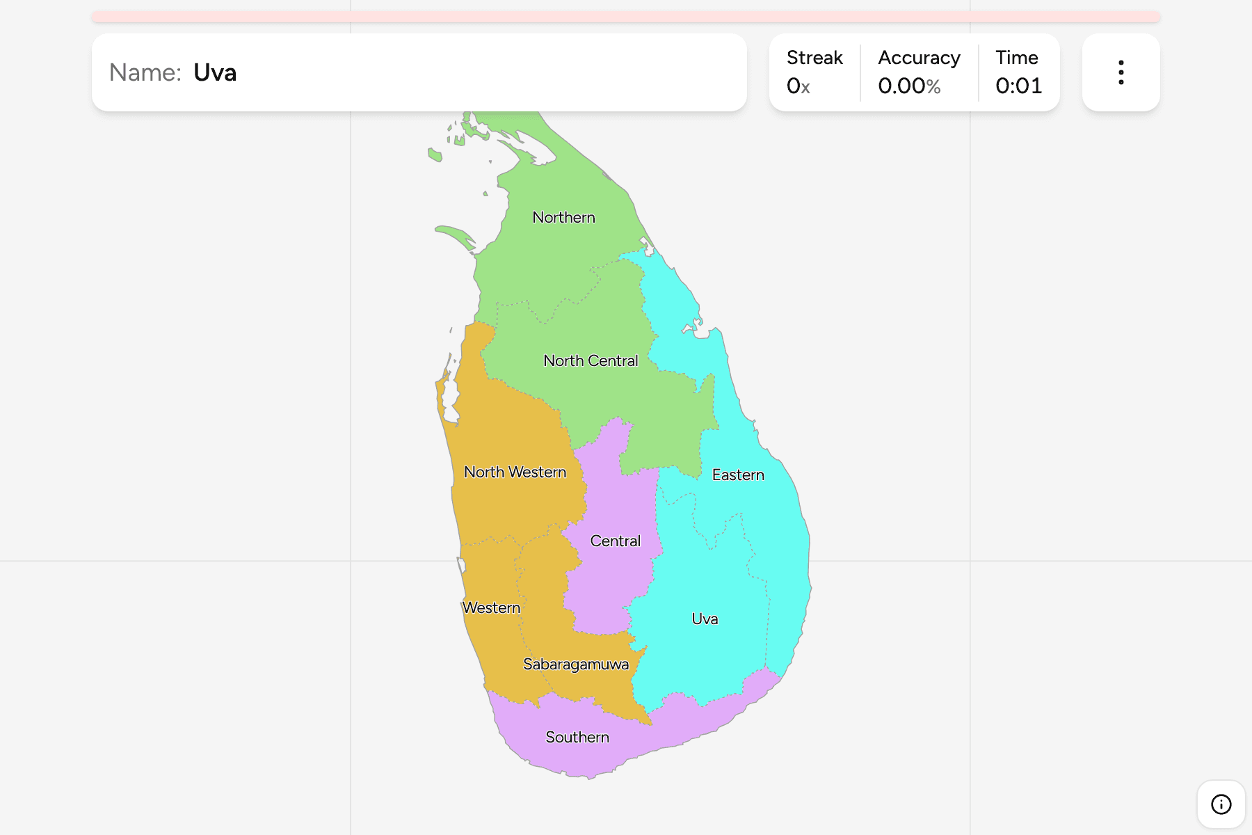
The provinces of Sri Lanka, the first tier of the country. Most are named for
where they sit: Northern, Eastern, Central, Southern, Western, North Western and
North Central. The other two are named for a place. Uva is the south-eastern
hill country, and Sabaragamuwa is the gem-mining belt on the south-western
slopes of the highlands.
The provinces are the Sri Lanka Districts grouped, so the
borders of the two maps match exactly. Colombo, the commercial capital, is in the
Western Province, and the official capital, Sri Jayawardenepura Kotte, is a few
kilometres inland of it, in the same province.
The groups are not an official classification. Sri Lanka has no tier between the
province and the country, so the quiz cuts the nine into the north, the east,
the west and the south with the hills, to let you drill the island a piece at a
time.
How to place one
- Start with the north. The Northern Province is the whole top of the island,
including the Jaffna peninsula, and North Central runs across the middle of the
dry zone beneath it.
- Find the east coast. The Eastern Province is the long strip on the Bay of
Bengal, with Uva behind it inland.
- Read the west as a coast. Western is the small, crowded province around
Colombo, with North Western above it and Sabaragamuwa inland.
- Finish with the hills. Central is the highland in the middle, and Southern
is the coast from Galle round to the south east.
Every province, by group
- North2 provinces
- North Central, Northern
- South and hills2 provinces
- Central, Southern
- East2 provinces
- Eastern, Uva
- West3 provinces
- North Western, Sabaragamuwa, Western
Worked examples
WesternThe small one with the capitalThe Western Province is one of the smallest on the island and by far the most
populous. It holds Colombo, the airport at Katunayake and most of the country's
industry, packed along the coast between the Kelani and Kalu rivers.
NorthernThe long way upThe Northern Province is the part of the map that is easiest to lose: it hangs
off the top of the island, ends in the Jaffna peninsula, and reaches across
Palk Strait to within sight of India.
Frequently asked questions
How many provinces does Sri Lanka have?
Nine. They were created in 1987, and the Northern and Eastern provinces were merged and then split again between 1988 and 2006.
Why are the groups not official?
Sri Lanka has no administrative tier between the provinces and the country, so the quiz groups the nine into four parts of the map by position.
What is below the province?
The districts, which number 25. They are their own quiz.
The tier below this one is Sri Lanka Districts. For
another country at this level, see Bangladesh Divisions.
Sources