Iran is one of the twenty largest countries in the world and its provinces are
unusually hard to place for one reason: the country is a ring. A high plateau
sits in the middle, mountains wall it in on the north, west and south, and the
cities that matter are strung around the rim and along the old caravan roads
between them. A province is rarely the place you have heard of. This page is the
31 that exist, the groups worth learning them in, and the traps that come with
a map this size.
- The quiz
- Name to place, on the map
- Where it helps
- News, travel, plates and road signs written in Persian
- In the game
- 31 provinces
What you are looking at
Iran is divided into 31 provinces, called ostans. Each is run by a governor
general appointed by the interior ministry, and each is named, with one or two
exceptions, after its capital city or the region around it. They sit above the
counties (shahrestans), which are the tier most Iranian addresses and plate
codes work at, and the counties sit above districts and rural districts.
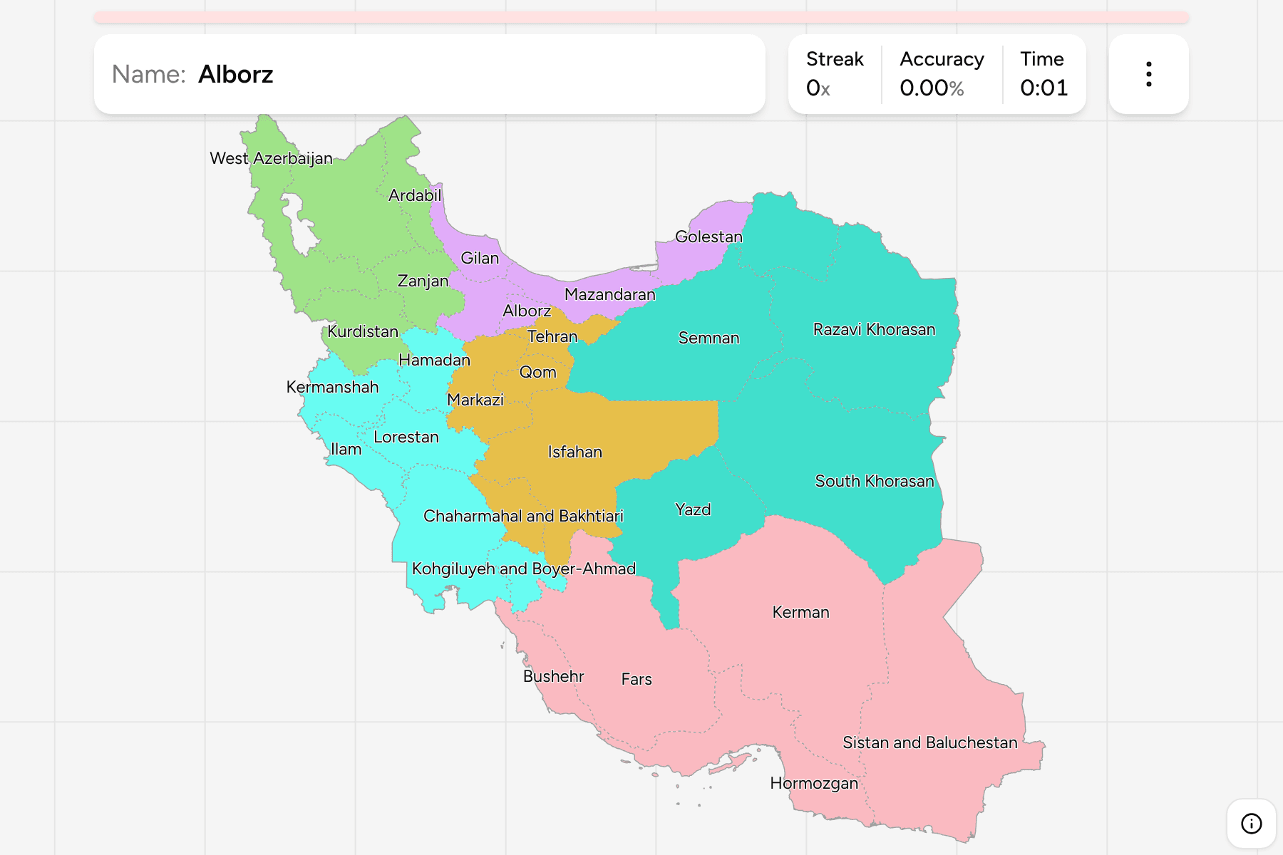
The newest of the 31 is Alborz, split off from Tehran province in 2010 around
the city of Karaj. Before that the country had 30, and a good deal of older
material, including some atlases and datasets, still draws Alborz as part of
Tehran. Before 2004, Khorasan was a single province covering the whole of the
north-east; it was divided into three, and those three are now North Khorasan,
Razavi Khorasan (named for the shrine at Mashhad) and South Khorasan. If a map
shows one Khorasan, it is older than this one.
Two kinds of name. Most provinces are named for a city: Tehran, Qom, Yazd,
Kerman, Hamadan. The rest are names of regions or peoples that are older than
the city: Khuzestan, Lorestan, Kurdistan, Gilan, Mazandaran, Fars, which
gave its name to the Persian language. The second kind is easier to place by
sound, since they say who lives there.
How to place one
- Start with the Caspian. The thin green strip under the Alborz mountains
is Gilan, Mazandaran and Golestan, in that order from west to east. It is wet
and forested and nothing like the rest of the country, and it is the only
part of Iran with a northern coast.
- Then the Persian Gulf coast. Khuzestan, Bushehr, Fars (which reaches the
coast only at its edge), Hormozgan and Sistan and Baluchestan run in a
curve from the Iraqi border to the Pakistani one, and Hormozgan holds the
islands in the strait.
- Then the three Azerbaijani and Kurdish provinces in the north-west. West
Azerbaijan, East Azerbaijan and Ardabil sit against Turkey, Armenia and the
Republic of Azerbaijan, with Kurdistan just south of them.
- Then the interior. The central plateau is the large empty middle of the
map, held by Kerman, Yazd, Isfahan and Semnan, and it is dry. The cities of
Isfahan and Yazd are oases on its edge rather than anything you would call
inland.
- Then the east. The three Khorasans stack from north to south against
Turkmenistan and Afghanistan.
The traps are the size mismatches. Alborz and Qom are tiny and sit next to
Tehran, which is itself small by Iranian standards, while Kerman and Sistan and
Baluchestan are among the largest and together fill most of the south-east.
Every province, by group
- North-west5 provinces
- Ardabil, East Azerbaijan, Kurdistan, West Azerbaijan, Zanjan
- Caspian5 provinces
- Alborz, Gilan, Golestan, Mazandaran, Qazvin
- West6 provinces
- Hamadan, Ilam, Kermanshah, Khuzestan, Kohgiluyeh and Boyer-Ahmad, Lorestan
- Centre5 provinces
- Chaharmahal and Bakhtiari, Isfahan, Markazi, Qom, Tehran
- East5 provinces
- North Khorasan, Razavi Khorasan, Semnan, South Khorasan, Yazd
- South5 provinces
- Bushehr, Fars, Hormozgan, Kerman, Sistan and Baluchestan
Those six groups are this site's, not Iran's. The country publishes a
grouping of its provinces into planning regions, but they are administrative
conveniences that nobody names a province by. The six here are cut for drilling:
each is a contiguous piece of the country somebody could point at, and each can
be switched on and off on its own in the game's start dialog.
North-west is the two Azerbaijans, Ardabil, Zanjan and Kurdistan. Caspian
is the wet north, from Gilan east to Golestan, with Qazvin and Alborz behind
the mountains. Centre is the capital and the plateau cities around it.
West is the Zagros, down to the Khuzestan plain. East is the three
Khorasans with Semnan and Yazd. South is the Gulf coast and the south-eastern
desert.
Worked examples
KhuzestanThe one on the Iraqi border with the oilKhuzestan: the flat, hot plain at the head of the Persian Gulf, with Ahvaz as
its capital and the Karun, Iran's largest river, running through it. It is
the only part of the Mesopotamian lowland inside Iran, and it looks like
Iraq, not like the mountains that surround it on three sides. Most of the
country's oil is under it.
HormozganThe coast with the islandsHormozgan: a long, narrow strip along the Strait of Hormuz, with Bandar Abbas
as its capital. Qeshm, Kish and the other islands in the strait belong to it.
The coastal plain is hot and humid and backed by mountains almost immediately,
which is why the province is so thin.
AlborzThe newest, and the smallestAlborz: the smallest province by area, a patch of land west of Tehran around
Karaj, split from Tehran in 2010. It is the one most likely to be answered as
Tehran, and the other way round.
Frequently asked questions
How many provinces does Iran have?
31. The most recent change was in 2010, when Alborz was created from Tehran province, taking the count from 30 to 31. Before 2004 Khorasan was a single province, and it was divided into North Khorasan, Razavi Khorasan and South Khorasan.
What are Iranian provinces called?
Ostans. Each ostan is divided into counties, called shahrestans, and those into districts (bakhsh) and rural districts (dehestan). The game accepts the English spelling and, if you switch it on in the start dialog, the Persian name.
Which is the largest province of Iran?
Kerman and Sistan and Baluchestan are the two largest, each well over 150,000 square kilometres, and between them they fill most of the south-east of the country. The smallest by area is Alborz, followed by Qom.
Why does this quiz not include the counties?
Iran creates and renames counties regularly, and the most recent boundary file available to this site draws 429 of them from 2019, against about 445 today. A map of the counties would be missing recently created ones, so there is no counties quiz until a current source exists. The 31 provinces are unaffected.
Which Iranian provinces are easiest to confuse?
Alborz and Tehran, since one was split from the other in 2010 and they share a border near the capital. The three Khorasans, which stack from north to south along the eastern border. And Kerman against Sistan and Baluchestan, which are both enormous and desert and sit side by side.
The other Asian administrative trainers here are Indonesia
Provinces, Israel Subdistricts
and Japan Prefectures. For a map of a similar size, try
Turkey Provinces and Morocco Regions.
Sources