Lithuania is the largest of the Baltic states and a country with very little
relief: lowland, forest, lakes and farmland from the Baltic coast to the
Belarusian border. Knowing you are in Lithuania says little about where, so the
county, or apskritis, is the first unit worth knowing. This page and the game
cover all ten, and the clues that tell you which one you are standing in.
- The quiz
- Name to place, on the map
- Grouped by
- Each county is its own group
- In the game
- 10 counties
What you are looking at
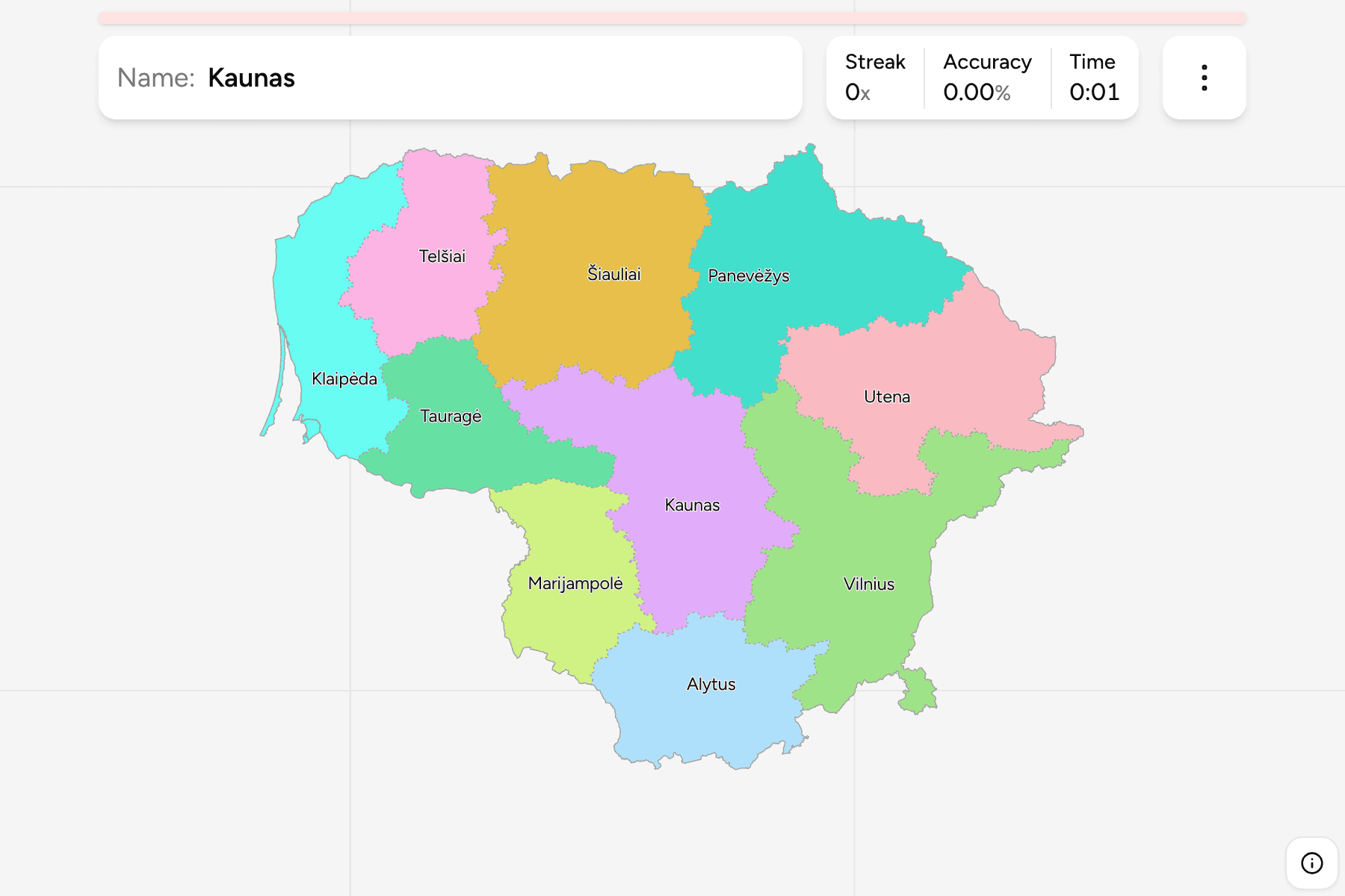
Each county is named after its main city, and the ten are Alytus, Kaunas,
Klaipėda, Marijampolė, Panevėžys, Šiauliai, Tauragė, Telšiai, Utena and
Vilnius. They have been the top tier of the country's territorial division since
the 1990s, but they are no longer a layer of government: the county governors'
administrations were abolished in 2010, and the municipalities beneath them now
do the work. The counties survive as the statistical regions of the country and
as the tier that plates, statistics and the Lithuanian address system still
refer to.
The names are written with Lithuanian letters, and the game asks for them
that way: Klaipėda, Marijampolė, Panevėžys, Šiauliai, Tauragė and Telšiai.
Vilnius County is not just the area round the capital. It runs from the
Belarusian border in the south, past Vilnius, up to the north east corner of the
country at Švenčionys, and across to Ukmergė in the west. Utena County, which
looks as though it should hold the north east, is the part just north of it.
How to place one
- Start from the coast. Klaipėda County is the only one on the Baltic, with
the port city and the Curonian Spit.
- Then the capital and the second city. Vilnius is in the south east, close
to the Belarusian border, and Kaunas is the centre of the country, where the
Nemunas and the Neris meet.
- Then the south. Alytus and Marijampolė are the two southern counties, on
the borders with Belarus, Poland and the Kaliningrad region of Russia.
- Then the north. Šiauliai and Panevėžys run across the north towards Latvia,
with Utena in the north east, and Telšiai and Tauragė fill the west between
them and the coast.
Every county
- Vilnius1 county
- Vilnius
- Kaunas1 county
- Kaunas
- Klaipėda1 county
- Klaipėda
- Šiauliai1 county
- Šiauliai
- Panevėžys1 county
- Panevėžys
- Utena1 county
- Utena
- Alytus1 county
- Alytus
- Marijampolė1 county
- Marijampolė
- Tauragė1 county
- Tauragė
- Telšiai1 county
- Telšiai
Worked examples
KlaipėdaThe one on the seaKlaipėda: the only county with a coast, the port of Lithuania and the home of
the Curonian Spit, the sand strip shared with the Kaliningrad region. Anything
on the Baltic is this one.
VilniusThe one that reaches northVilnius County: the capital and its district, the border with Belarus, and a
tail that reaches to the north east. Trakai with its island castle is in it,
and so is Švenčionys, far from Vilnius itself.
TauragėThe small one in the westTauragė: a small county in the west, along the Nemunas where the river forms
the border with the Kaliningrad region. Anything on that stretch of the river
is this one or Marijampolė.
Frequently asked questions
How many counties does Lithuania have?
Ten: Alytus, Kaunas, Klaipėda, Marijampolė, Panevėžys, Šiauliai, Tauragė, Telšiai, Utena and Vilnius. Each is named after its main city.
Do Lithuanian counties still have a government?
No. The county governors' administrations were abolished in 2010. The counties remain as a territorial and statistical division, and the municipalities below them carry out local government.
Which county is the capital in?
Vilnius County, in the south east of the country near the Belarusian border.
Which county is on the coast?
Klaipėda County is the only one with a Baltic coast, and it includes the Lithuanian half of the Curonian Spit.
Which Lithuanian counties are easiest to confuse?
Vilnius and Utena in the east, because Vilnius County reaches round Utena's southern edge, and Šiauliai and Telšiai in the north west.
The tier below this one is Lithuania Municipalities,
and the ten counties are its groups. The other European administrative maps here
are Slovenia Regions, Denmark Regions
and Poland Voivodeships.
Sources