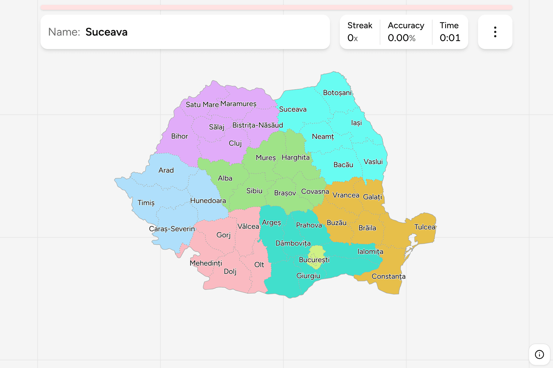
Romania's counties are easier to learn as historical provinces than as shapes.
The country was assembled from Wallachia, Moldavia, Transylvania and a few
smaller lands, and the county map still follows those seams: the Carpathians
split the interior from the plains, and most counties sit on one side of that
arc or the other. Learn where the arc runs and where the Danube turns, and the
map falls into place. This page is the whole set, and the game asks you to put
each name where it belongs.
- The quiz
- Name to place, on the map
- Groups
- The eight development regions
- In the game
- 42 counties
What you are looking at
A județ is Romania's top level of local government. Each has an elected county
council and a prefect appointed by the national government, and each takes its
name from its capital city or from a river or mountain, with the exceptions
that make it worth learning: Bistrița-Năsăud and Caraș-Severin are two
places joined into one name, and Maramureș is a historical land. Bucharest is not part of any county. It is a municipality
with county rank, and the county of Ilfov wraps around it on every side.
Counties were restored in 1968, after eighteen years in which the communist
state had replaced them with regions on the Soviet model. The map has barely
moved since, so most of the names match the pre-war ones. The statistical
grouping above the counties is the eight development regions, which are not
governments at all: they exist to share out European funds and to publish
statistics, and they are what this game uses for its groups.
The best clue on the ground is the number plate. A Romanian plate starts with a
one or two letter code for the county, which is the same code the ISO list
uses: B for Bucharest, CJ for Cluj, TM for Timiș, CT for Constanța. Like the
rest of the road system it is otherwise national, so the plate is the one
regional marker a photo is likely to carry.
How to place one
- Start with the arc. The Carpathians bend from the north through the
centre and back west to the Danube. Inside the bend are the Transylvanian
counties, outside it are Moldavia to the east and Wallachia to the south.
- Then the two coasts. Constanța is the Black Sea county in the southeast,
and Tulcea above it is the Danube delta, the only county that is mostly
water and reed.
- Then the capital. Bucharest and Ilfov are on the southern plain, in the
middle of Wallachia, a short way north of the Danube and its border with
Bulgaria.
- Then the corners. Satu Mare and Maramureș are the northwest, up against
Ukraine and Hungary. Botoșani is the northeast corner. Timiș is the
southwest, the largest county in the country, on the Serbian and Hungarian
border. Giurgiu and Teleorman are the Danube counties facing Bulgaria.
- Fill in the middle. What is left is the cluster of mountain counties in
the centre: Alba, Sibiu, Brașov, Mureș, Harghita and Covasna.
Two pairs cause most of the mistakes. Dâmbovița and Dolj both begin with a D
and sit on opposite sides of the Olt, one beside Bucharest and one far to the
west. And Argeș, Arad and Alba are three A counties in three parts of the
country, in the south, the west and the centre.
Every county, by development region
- Centru6 counties
- Alba, Brașov, Covasna, Harghita, Mureș, Sibiu
- Nord-Vest6 counties
- Bihor, Bistrița-Năsăud, Cluj, Maramureș, Sălaj, Satu Mare
- Nord-Est6 counties
- Bacău, Botoșani, Iași, Neamț, Suceava, Vaslui
- Sud-Est6 counties
- Brăila, Buzău, Constanța, Galați, Tulcea, Vrancea
- Sud-Muntenia7 counties
- Argeș, Călărași, Dâmbovița, Giurgiu, Ialomița, Prahova, Teleorman
- Sud-Vest Oltenia5 counties
- Dolj, Gorj, Mehedinți, Olt, Vâlcea
- Vest4 counties
- Arad, Caraș-Severin, Hunedoara, Timiș
- București-Ilfov2 counties
- București, Ilfov
Each group can be played on its own from the start dialog. The regions are the
best way in: six or seven counties at a time is a manageable bite, and the
groups line up with the historical lands rather than cutting across them.
Worked examples
IlfovThe ring around the capitalIlfov has no city of its own to point at, since its administrative centre is
Bucharest, which is not inside it. It is the small county that surrounds the
capital, and the way to place it is to place Bucharest first. It is also one
of the smallest counties by area, which makes it a tap target to aim for
rather than a shape to recognise.
TulceaMostly riverTulcea is the end of the Danube, where it splits into the delta before the
Black Sea. The delta is the largest and best preserved in Europe, and most of
the county is channels, lakes and reed beds that no road crosses. On the map
it is the county with a ragged eastern edge, above Constanța and east of
Galați.
TimișThe biggest oneTimiș is the largest county by area, in the far southwest on the border with
Serbia and Hungary, and its capital Timișoara is the city where the 1989
revolution began. It belongs to the historical Banat, a land shared with
Serbia and Hungary, which is why it is the one that feels furthest from
Bucharest.
CovasnaSmall and inlandCovasna is the small mountain county in the centre-east, up against the
curve of the Carpathians. It and its neighbour Harghita are the two counties
where the Hungarian-speaking Székely community is the majority, which is why
their names are often heard in two languages.
Frequently asked questions
How many counties does Romania have?
41, plus the municipality of Bucharest, which has the same rank as a county but is not part of any. The set has been the same since 1968, when counties were restored after the communist period of regions, and that is why the game has 42 targets.
What is a județ?
The Romanian word for a county, and the top level of local government. Each has an elected council and a prefect appointed by the government, who represents the state in the county. The next level down is the commune, of which there are over three thousand, which is too many for a map game.
What are the eight development regions?
A statistical and planning grouping of the counties, used to distribute European Union funds. They have no government of their own. Seven are blocks of four to seven counties, and the eighth is Bucharest with Ilfov. They roughly follow the historical lands: Nord-Est is Moldavia, Sud-Muntenia and Sud-Est are Wallachia and the Danube coast, and Centru and Nord-Vest are Transylvania.
How can you tell which county a photo is in?
The number plate, which begins with the county code: B for Bucharest and IF for Ilfov, CJ for Cluj, BV for Brașov, and so on. It is the one regional signal in the picture, since signs, markings and bollards are the same across the country.
Which county is the largest?
Timiș, in the southwest, by area. Ilfov is the smallest county, and Bucharest, which is not a county, is smaller still. Bucharest is also the most populous by a wide margin.
Which Romanian counties are easiest to confuse?
Dâmbovița and Dolj, which share an initial and sit far apart. Argeș, Arad and Alba, three A counties in the south, the west and the centre. And Vâlcea with Vrancea, which look alike on a list and are in the southwest and the east.
More European maps in the same shape: Poland Voivodeships,
Portugal Districts and Ireland Counties.
Sources