Zimbabwe is a plateau between two rivers, the Zambezi on the north and the
Limpopo on the south, with the Eastern Highlands standing along the Mozambique
border. The province is the unit that tells you which part of that plateau a
round is on, and there are ten of them.
- The quiz
- Name to place, on the map
- Grouped by
- Three parts of the country, an unofficial cut
- In the game
- 10 provinces
What you are looking at
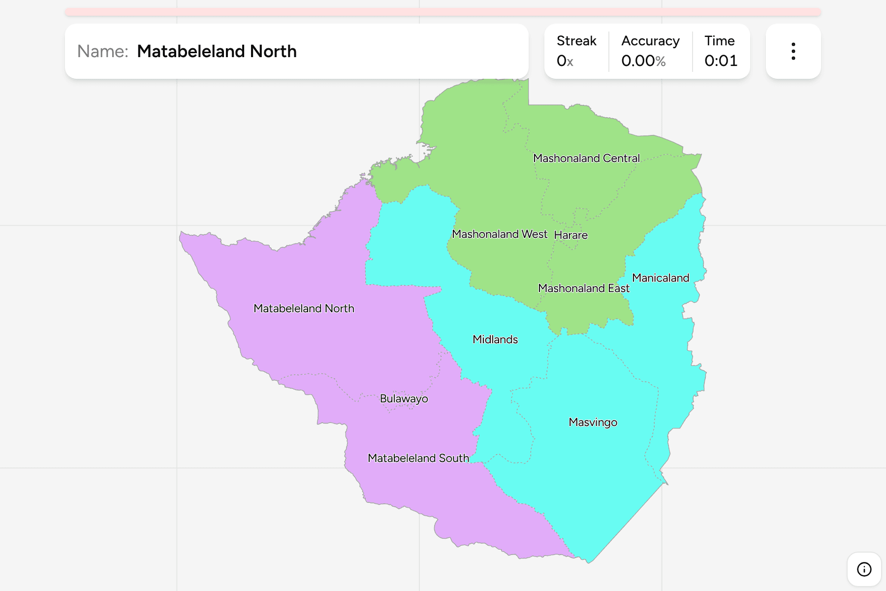
The provinces of Zimbabwe: eight that cover the country, and two cities,
Harare and Bulawayo, that have provincial status and are no bigger on the map
than a dot. They are drawn here with a tap area, so you can reach them.
The names tell you the layout. Mashonaland is the north and east, home of the
Shona, in three provinces round Harare. Matabeleland is the south west, in two
provinces round Bulawayo. The Midlands runs through the middle, Masvingo lies to
the south east, and Manicaland holds the highlands on the Mozambique border.
The groups are not an official classification. Zimbabwe has no tier between the
province and the country, so the quiz cuts the ten into Mashonaland,
Matabeleland, and the centre and east, to let you drill it a piece at a time.
The provinces are the Zimbabwe Districts grouped, so the
borders of the two maps match exactly.
Lake Kariba, on the Zambia border, is not part of any district in the boundary
file and is left as a gap in the map.
How to place one
- Start with the two cities. Harare is the capital, in the north east of the
plateau, and Bulawayo is the second city, in the south west. Everything else
is placed relative to them.
- Read the north as Mashonaland. Mashonaland West, Central and East run
along the Zambezi side and round Harare.
- Read the south west as Matabeleland. Matabeleland North reaches the
Zambezi at Victoria Falls, and Matabeleland South runs down to the Limpopo.
- Leave the middle for last. The Midlands, Masvingo and Manicaland are the
plain-looking bands between the two halves, and Manicaland is the one against
the Mozambique border.
Every province, by group
- Mashonaland4 provinces
- Harare, Mashonaland Central, Mashonaland East, Mashonaland West
- Matabeleland3 provinces
- Bulawayo, Matabeleland North, Matabeleland South
- Centre and east3 provinces
- Manicaland, Masvingo, Midlands
Worked examples
ManicalandThe one on the highlandsManicaland is the eastern province, on the border with Mozambique, and the
one that holds the Eastern Highlands. Its capital is Mutare.
BulawayoThe city that is a provinceBulawayo is the second city and a province of its own, surrounded by
Matabeleland North and South. It is small on the map, so the quiz gives it a
tap area.
Matabeleland NorthThe one on the ZambeziMatabeleland North is the largest province in the west, with Victoria Falls
and Hwange National Park inside it, and Lake Kariba along part of its northern
edge.
Frequently asked questions
How many provinces does Zimbabwe have?
Ten: eight rural provinces, and Harare and Bulawayo, which are cities with provincial status.
Where do the groups come from?
They are an unofficial cut into three parts of the map, so you can drill a piece at a time. Zimbabwe itself has no tier between the province and the country.
Why is there a gap in the north?
Lake Kariba is not a district, so the boundary file leaves it out and the map shows it as water.
The tier below this one is Zimbabwe Districts. For
another country at this level, see Cambodia Provinces.
Sources